Three Hidden Gems of the Reykjanes Peninsula
There used to be a time when almost the whole of the Reykjanes peninsula beyond the airport and the Blue Lagoon could have been considered a hidden gem. But times change and as tourist numbers have increased, sites have become more popular. The unexpected volcanic eruption at Fagradalsfjall in 2021 and subsequent lava flows have shone the spotlight on this part of the region too, encouraging more visitors to hang around for a while before continuing on to Reykjavik and beyond.
As more and more people discover this part of Iceland, they seek to venture beyond its major attractions, even on a first visit. Social media and the internet make it easy for recommendations to be shared, which fuels this need to find hidden gems and secure their bragging rights. Though maybe what’s driving you is simply a desire for solitude, the opportunity to find your own little corner of the Reykjanes peninsula and pretend that you might have it to yourself.
Happily there are some spots in this Icelandic region that are still largely overlooked by travellers. We’d like to demonstrate why they don’t deserve to be underrated and introduce you to three of these hidden gems of the Reykjanes peninsula. Between them, they illustrate the natural beauty of the area and fill in some of the historical and cultural context that makes this part of Iceland such a rewarding place to explore.

Grænavatn
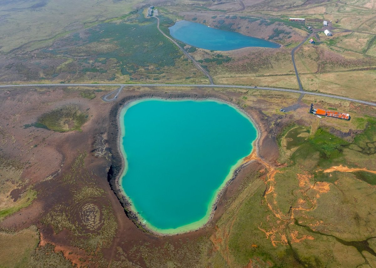
Iceland is blessed with many lakes; the largest of the Reykjanes peninsula is Kleifarvatn which is also a haven for birdlife. If you’re in search of a hidden gem, instead head over to Grænavatn. The name itself is the first clue to why you should seek it out. Grænavatn means “green lake” and is a vivid shade of teal, especially in the centre of the lake where it is deepest.
This lake is situated just to the south of Seltún, part of the geothermal area within Krýsuvík. Originally, this was a crater formed about 6000 years ago, possibly when superheated underground water exploded out of the ground. The intense colour comes from the high sulphur content of the water that has since collected in this hollow as well as the presence of algae.
Though it’s relatively deep – 45 metres at most – it’s not a large lake, which means you can easily walk right around it in around twenty minutes or so. The place isn’t completely natural, as there are a few dilapidated buildings beside the water. These are abandoned silage towers and a cowshed that have never been torn down but have been this way for decades.
Grænavatn is not the only crater lake to have been formed in this way. Nearby, you’ll find a smaller body of water called Gestsstaðavatn. It’s highly probable that this was created at the same time, as were Augun (the eyes). Because of the way magma moves underground, it isn’t unusual for volcanic craters to be clustered in this way. Allow enough time to stroll around the area and see them all if you can.
Garðskagi
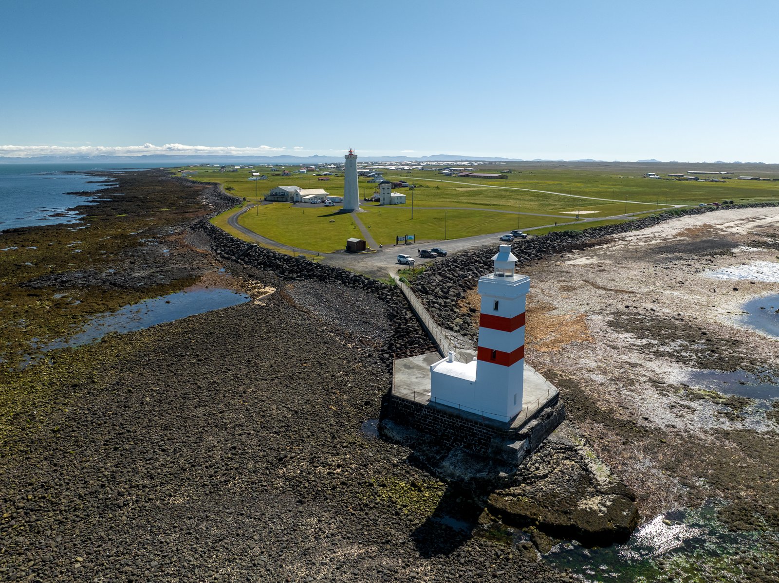
The wild and windswept coastline in the south west of Iceland contains another overlooked gem that’s worth a detour, Garðskagi headland. It’s barely a few miles from Keflavik Airport but as the majority of traffic turns right rather than left, hardly any visitors make it to this remote-feeling place. But that’s such a pity.
Now, the waters off the Reykjanes peninsula would be treacherous to maritime traffic in bad weather if it weren’t for the lighthouses that alert ships to the rocks that line the shore and lie partly submerged in the foamy shallows. Reykjanesviti is the headliner; this was the first place in Iceland to get a lighthouse. In a 2017 popularity poll, it came top among Icelanders, getting the lion’s share of the vote.
But in the shadow of the favourite are another pair and you’ll find them both within sight of each other at Garðskagi. The older lighthouse is squat and square, painted white with distinctive red stripes. It perches right at the north western tip of Reykjanes. Just inland there’s a taller and newer lighthouse, which is more cylindrical and all white.
In the daytime, you can have a good look at the outside of the two lighthouses, but the area is also suitable for birdwatching. It’s also a good spot to come on a dark night if you’re visiting outside the summer months. That’s because there’s very little light pollution to hinder a sighting of the Northern Lights; those lighthouses will help you focus your shot too, an added benefit.
Garður village also has a cute church called Útskálakirkja. It was built in 1863 and enlarged in the 20th century, but a church has probably stood on this spot for more than 800 years. Inside, there are pretty paintings including one of the Annunciation of Mary. The churchyard contains the graves of more than 40 souls that perished at sea in 1685, showing just how important those lighthouses are.
The village is named after a wall that led from Kirkjuból to Útskálar. This wall would have consisted of stones and turf. Its function would have been to separate sheep from the nearby crops and thus protect the locals’ food supply. These days, you’ll see grass in place of barley, wheat or oats.
Selatangar
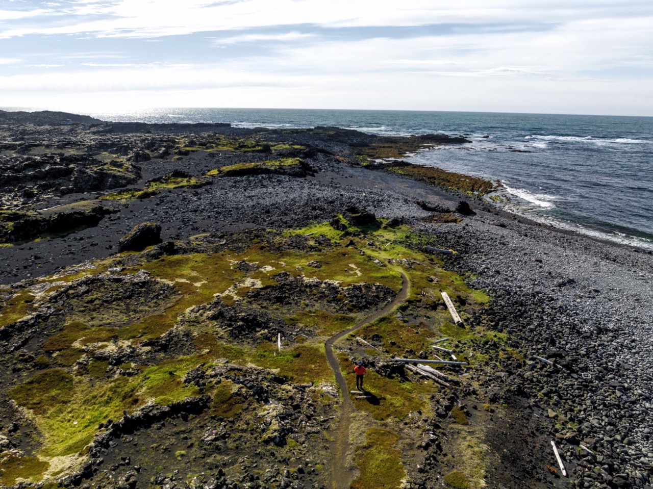
Our next pick is Selatangar. It is situated midway between the town of Grindavik and the Krýsuvíkurbjarg cliffs. Look closely among the rocky landscape and you’ll realise that the stones here are not randomly scattered, but more carefully placed. That’s because you are looking at the remains of a fishing station called Selatangar – only the foundations still exist.
The origins of this fishing station are a little hazy but as there is evidence of a lava flow dating from the 12th century historians agree it can’t have been constructed earlier than that. Early fishing was done in rowing boats and those that toiled in this way needed to have somewhere close to shore when they landed their catch. It’s thought that the place was abandoned after 1884.
Fishing stations like this were built along various parts of the Icelandic coast. Typically Selatangar and places like it would have been used from February through to May. Some of the buildings would have been a place for them to rest, others stores for drying their hard-won stockfish catch. Once summer came, the fishermen were needed on land to help harvest the hay. But remember how dark this would have felt in the depths of winter.
It would have been a horribly tough existence; to say this place would have been basic is an understatement. Those who slept here would have had no electricity or running water. As storms raged and the wind howled, it would have been hard to get a decent night’s rest, no matter how tired you were. How they endured such hardship is difficult to imagine from our comfortable 21st century perspective.
In such conditions, it’s easy to see how tales of ghosts and spirits could quickly take hold. Like Gunna at Gunnuhver, there’s thought to be a ghost here. Its name is Tanga-Tómas, whose mission was to terrorise the fishermen at Selatangar. Perhaps it’s still here, so it’s probably best (and safest!) to visit during daylight just in case.