Skip to content

Or try searching by Category and/or Location

The Mid-Atlantic ridge comes ashore on the Reykjanes peninsula.

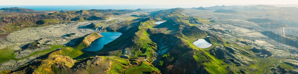
The peninsula, with its diversity of volcanic and geothermal activity, is a Geopark and is the only place in the world where the Mid-Atlantic Ridge is visible above sea level.

The word geo is linked to the goddess Gaia, who was the personification of Earth in ancient Greek mythology. She was one of the primordial deities, the great mother of all, mother earth.

Reykjanes Geopark logo

Reykjanes Geopark lies on major plate boundaries along the Mid-Atlantic Ridge, part of the 65,000km mid-ocean ridge that encircles the earth like a seam of a baseball. Although 90% of this mountain range lies deep below the surface of the ocean, it rises above sea-level right here on the Reykjanes Peninsula, making this one of the only places on earth where it is visible.

It is home to many important geological formations, some of which are utterly unique, including numerous types of volcanoes in at least four separate volcanic zones, with hundreds of open fissures and faults.

The Reykjanes Peninsula is a continuation of the Mid-Atlantic Ridge, which rises from the sea at the very tip of the peninsula and diagonally crosses Iceland from the south-west to the north-east. You can read the area’s geological history several hundred thousand years back in time, although most of the strata are less than 100–200 thousand years old. The last series of eruptions on the Reykjanes Peninsula began around AD 1000 and ended 250 years later.

The landscape that makes up the peninsula is characterized by tuff mountains and hyaloclastite ridges that formed in subglacial eruptions, as well as several series of craters and other large shield volcanoes from more recent times. In many places, there are lava stacks that formed in fissure eruptions, when large volumes of lava flowed from craters in the faults. Eruptions in Reykjanes are rarely accompanied by ash except where the volcanic fissures opened underwater or in the sea.

Earthquakes are frequent due to the spreading of the plates and occur most commonly as earthquake swarms that can last for several years. Although most of these are minor, every so often they can be felt across the entire peninsula.

Reykjanes Unesco Global Geopark is the second geopark in Iceland and the 66th member accepted into the European Geoparks Network in September 2015.

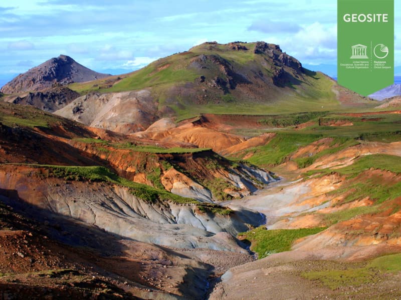
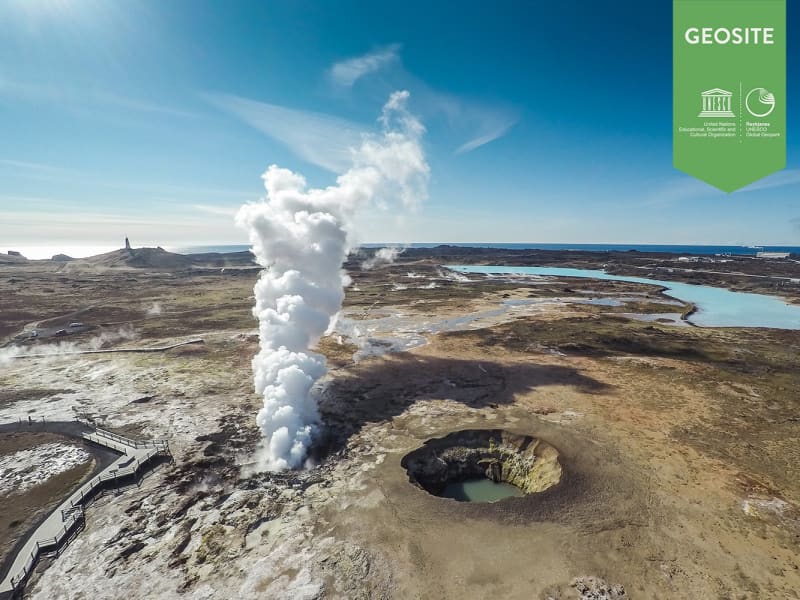
Reykjanes Geopark has listed 55 sites as Geosites. Those sites have a significant role in the Geopark and are connected to the story of the Mid Atlantic ridge and the effects of the tectonic plates.

Further information on the Reykjanes Geopark can be found on their website www.reykjanesgeopark.is.

European Geoparks Network logoReykjanes peninsula is now a Global UNESCO Geopark

Geosites
The Reykjanes Geopark has 55 areas listed as geosites. A geosite is an interesting site because of the geological, geographical or cultural history of the region. It plays a significant role in the interpretation of the Reykjanes Geopark and what it stands for.
Brimketill
Brimketill is a small, naturally carved pool, by marine erosion, at the lava shore edge west of the town of Grindavík. The folklore relates that the pond was regularly occupied by a giantess named Oddný. The viewing platform overlooking Brimketill is just a few steps away from the parking lot starting with a small set of stairs, making the platform inaccessible to wheelchairs. Standing on the platform you risk the possibility of getting soaked as the waves can almost reach the parking lot. Make sure to watch your step while taking in the amazing view and the unrelenting forces of nature. Utmost caution is recommended, especially when travelling with children.   The viewing platform has now been extended and gives visitors a better view over Brimketill. Safety information! There is no safety supervision of the area. Visitors travel at their own risk. The waves can be unpredictable and unexpected. Ocean currents in the area are extremely powerful. Strong blasts of wind can be dangerous and unforeseen. Never leave your child unattended. Hold it at all times on the viewing platform. Entering the sea may be life-threatening. Travel safely in Iceland. SafeTravel.is
Bridge Between Continents
Bridge between Europe and North America on Reykjanes Peninsula.   The lava-scarred Reykjanes peninsula lies on one of the world's major plate boundaries, the Mid Atlantic Ridge. According to the continental drift theory the Eurasian and North American tectonic plates are continuously drifting apart with great forces under the gaping rifts. As the plates diverge, linear fractures, known as fissures form due to stresses created by the tension that builds up as the plates move away from each other. The Bridge between two continents at Sandvík is a small footbridge over a major fissure which provides clear evidence of the presence of a diverging plate margin. The bridge was built as a symbol for the connection between Europe and North America. One can cross the continental divide on Leif the Lucky's Bridge and take home a personalised certificate at the Reykjanes information center and Reykjanes Geopark visitor center at Duus Cultural house. 
Grænadyngja and Trolladyngja
Grænadyngja and Trölladyngja are steep hyaloclastite mountains west of the Sogin geosite. They are surrounded by young volcanic fissures, geothermal sites and beautiful colours. The two mountains are associated with various lava flows, including Afstapahraun close to the Keflavík International Airport main road. Four kilometers on road 41 east from Mt. Keilir.
Kleifarvatn
Lake between Sveifluháls and Vatnshlíð.  The lake Kleifarvatn is about 10 km². It is the largest of Reykjanes peninsula and the third largest of southern Iceland. It is about 97 m deep and one of the deepest lakes in Iceland.  Its catchment area is small and it has a very limited discharge on the surface. The lake has diminished since year 2000 because of two major earthquakes, which probably opened up fissures at its bottom. In the sixties char fries from Lake Hlidarvatn were released into the lake and have thrived quite well. In the southernmost part a hot water from some hot springs runs into the lake but elsewhere the lake is very cold. A small fishing lodge is located by the lake. Great place for photographers because of the volcanic surroundings of the lake are unique and beautiful. The story says that  a monster in the shape of a worm and size of a medium sized whale lives in the lake.
Gunnuhver
The mud pools and steam, vents in south-west Reykjanes. The area is close to Reykjanes lighthouse and is collectively named Gunnuhver after a female ghost that was laid there. She had caused great disturbance until a priest set a trap for her and she fell into the spring. This happened about 400 years ago. The mud pools take form where steam from boiling geothermal reservoir water emanates and condenses and mixes with surface water. Accompanying gases such as carbon dioxide and hydrogen sulphide make the water acid. This causes alteration of the fresh lava rock to clay. Steaming of the ground at Reykjanes increased markedly as a consequence of a pressure drawdown in the geothermal reservoir upon the start of production from the reservoir in 2006. Iceland´s largest mud pool at present prominent, highest up in the Gunnuhver group. It is 20 meters wide across a rim of mud, boiling vigorously. Two ramps are located at the Gunnuhver group, on close to Gunnuhver itself where you can look down to the spring and hear the vigorous noise, see the boiling water and feel the power bursting from the ground and the steam on your face. The other ramp is located on Kísilhól a silica hill. From there you have a good view over Gunnuhver group and surroundings. Gunnuhver stands in the heart of the Reykjanes UNESCO Global Geopark where the North Atlantic ridge rises from the ocean, you find 100 different craters and lava fields, bird cliffs, high geothermal areas, black sand beaches, The Bridge Between Continents, geothermal power plants, lighthouses, and exhibitions.