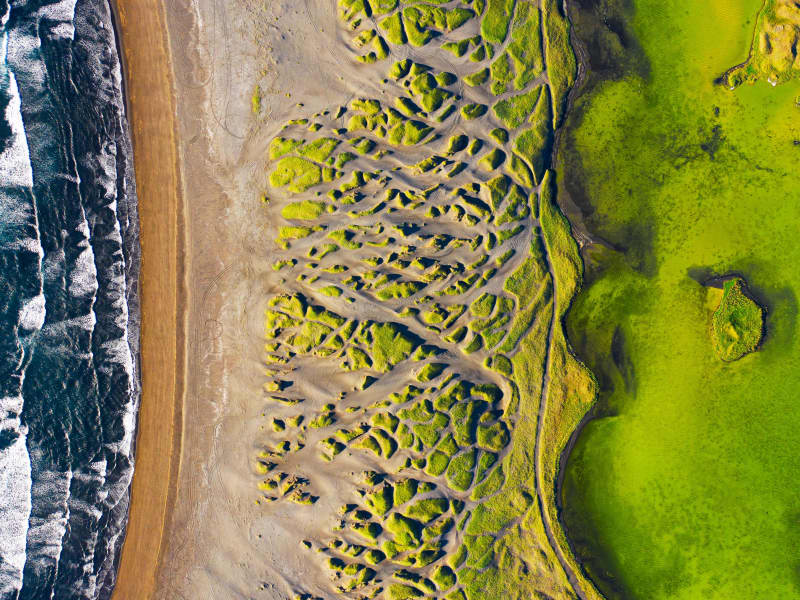
There are many scenic nature sites in the Reykjanes Peninsula that are worth exploring!

Mt Stapafell
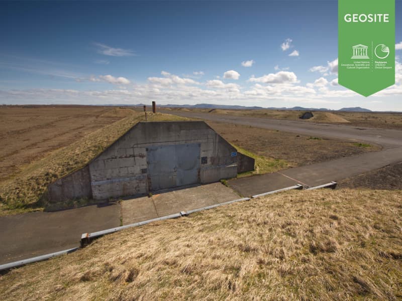
Mt Stapafell is a hyaloclastite mountain on the Reykjanes Peninsula to the southeast of the village Hafnir. It is mostly made of pillow lava. Olivine, one of the primary structures of the basaltic rock, dominates the lower part of the pillows. Just south of Mt Stapafell is the ancient main route between Grindavik and the fishing outfits of Rosmhvalanes ("The Walrus Spit"), where it is still possible to see the grooves of the feet of men and horses in the lava areas. Mt Stapafell has greatly diminished in size because of extensive quarrying and some of it is lying underneath the runways of the Keflavik Airport
View
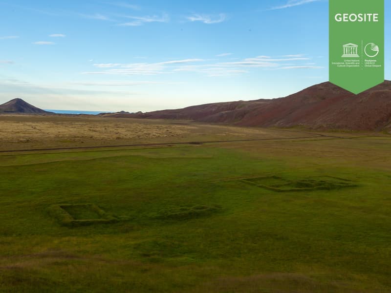
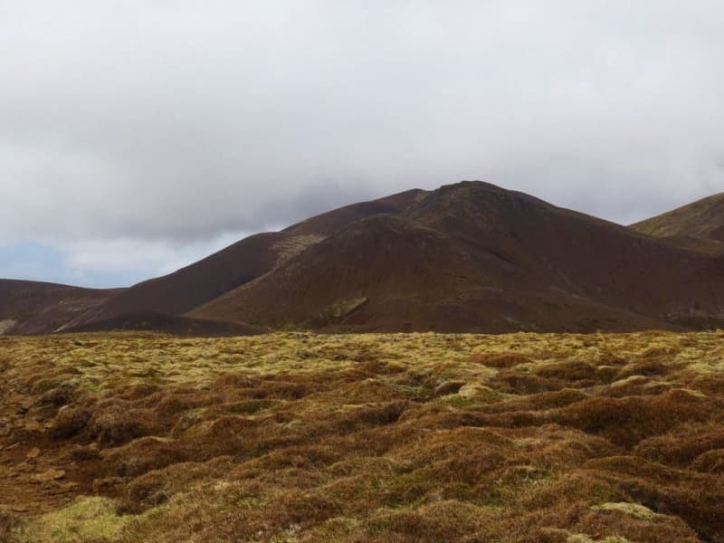
Vigdísarvellir
Ruins of the old farms Bali and Vigdísarvellir.
Camping site sorrounded by beautiful scenery.
Location: Road 428 closed on winter time.
View

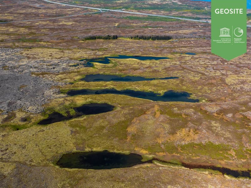
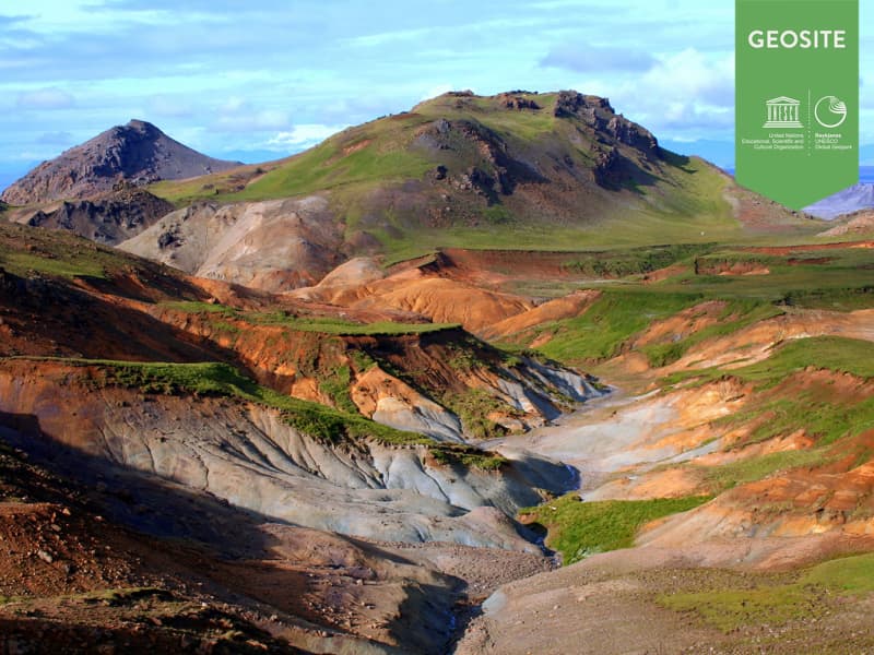
Djúpavatn, Spákonuvatn and Grænavatn
Three lakes in the hyaloclastite Ice Age ridges Vesturháls and Sveifluháls, contain groundwater. Djúpavatn is partly a crater lake, close to Djúpavatnsleið road, Spákonuvatn crater lake to the Sogin-geosite and Grænavatn to a marked path across Sveifluháls.
View

Hrafnagja
The normal fault and tension fracture, Hrafnagjá, is the longest of its kind at the Reykjanes peninsula. It is 12 km long and up to 30 m high. The set of fractures east of Vogar village forms a typical rift valley.
Location: Hrafnagjá is visible from Reykjanesbraut (road nr. 41) to Keflavík International Airport. A hikingtrail leads to the location from the parking place by the intersection of the town Vogar.
Hrafnagjá is a geosite in the Reykjanes Unesco Global Geopark.
View
Hvassahraunskatlar
Hvassahraunskatlar is a hornitos in the Hrútagjá lava shield flow. Hornitos usually form due to powerful degassing at crater edges. These ones, however, came into being approximately 10 km away from the top crater.
Hvassahraunskatlar is a geosite within Reykjanes Unesco Global Geopark.
View
Keilisnes
Keilisnes is a spit of land between the coves Flekkuvik and Kalfatjorn. On the Cairn Mound near the old main road stands a cairn called Stefansvarda. This spot offers an excellend panoramic view over the Faxi Bay.
Copy right: www.nat.is Used by permission
View
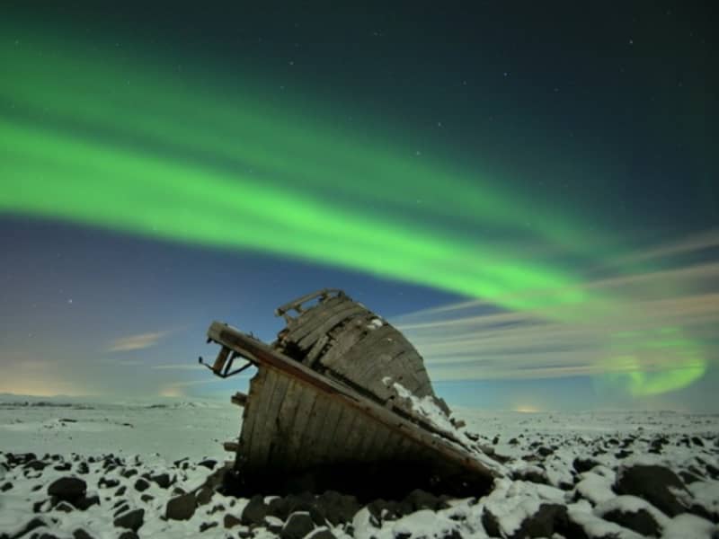
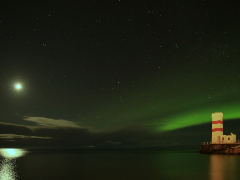
Northern lights - Aurora Borealis
Auroras are associated with the solar wind, a flow of ions continuously flowing outward from the sun. The Earth´s magnetic field traps these particles, many of which travel toward the poles where they are accelerated toward Earth. Collisions between these ions and atmospheric atoms and molecules causes energy releases in the form of auroras appearing in large circles around the poles. Auroras are more frequent and brighter during the intense phase of the solar cycle when coronal mass ejections increase the intensity of the solar wind. Seen from space, these fiery curtains form a thin ring in the shape of a monk´s tonsure.The Northern Lights occur high above the surface of the earth where the atmosphere has become extremely thin, in an altitude of 100-250km
In the past theories have been proposed to explain the phenomenon. These theories are now obsolete. Benjamin Franklin theorized that the mystery of the Northern Lights was caused by a concentration of electrical charges in the polar regions intensified by the snow and other moisture.
The first Old Norse account of norðrljós is found in the Norwegian chronicle Konungs Skuggsjá from AD 1230. The chronicler has heard about this phenomenon from compatriots returning from Greenland and he gives tree possible explanations: that the ocean was surrounded by vast fires, that the sun flares could reach around the world to its night side, or the glaciers could store energy so that they eventually became fluorescent.
Usually from late September until the beginning of April, the Northern Lights can be seen in Iceland in most places. In dark areas away from city lights these are best seen. Important one chooses the right evening with clear skies.
View
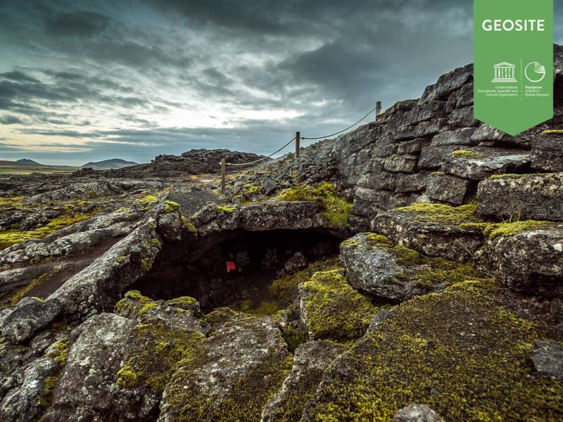
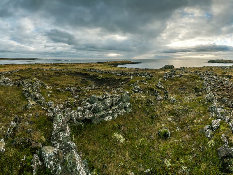
Eldvorp - Remnants of ancent settlement
Shelters made of rock, ancient paths and stacked walls.
They have been discoverd near Eldvörp, a row of scoria and spatter cones formed in the Reykjanes Fires 1210-1240 AD.
Location: Close to Eldvörp, walk from road 425.
View

Sandfellshæð
One of the oldest and largest lava shield on the Reykjanes peninsula. Formed in late glacial time, about 14.000 years ago, when sea level was about 30 m lower than today.
Only recommend going there on well-equipped jeeps. By foot it is possible to walk on road between Svartsengi and Reykjanes
View

Vogastapi
Vogastapi was named "The Heifer Cove Cliff", later "The Cove Cliff" and sometimes just "The Cliff" by the inhabitants of the area. It is an 80 m. high, dolerite hillock between Coves Vogavik and Njardvik. It is precipitous towards the sea, but has a gradual gradient inland. It is mostly sparsely vegetated and somewhat barren in places. The main road to the western communities crosses it. The view from its highest point, Grimsholl, is excellent and a view dial explains the topographical names of the surroundings. Up to this date the Vogastapi Area is haunted by a ghost, which has mislead people off the brink of the cliff. During the motorized age, some of the passers by have noticed a being carrying its head under its arm and sometimes drivers travelling alone spotted it in their rear view mirrors sitting in the back seats.
View
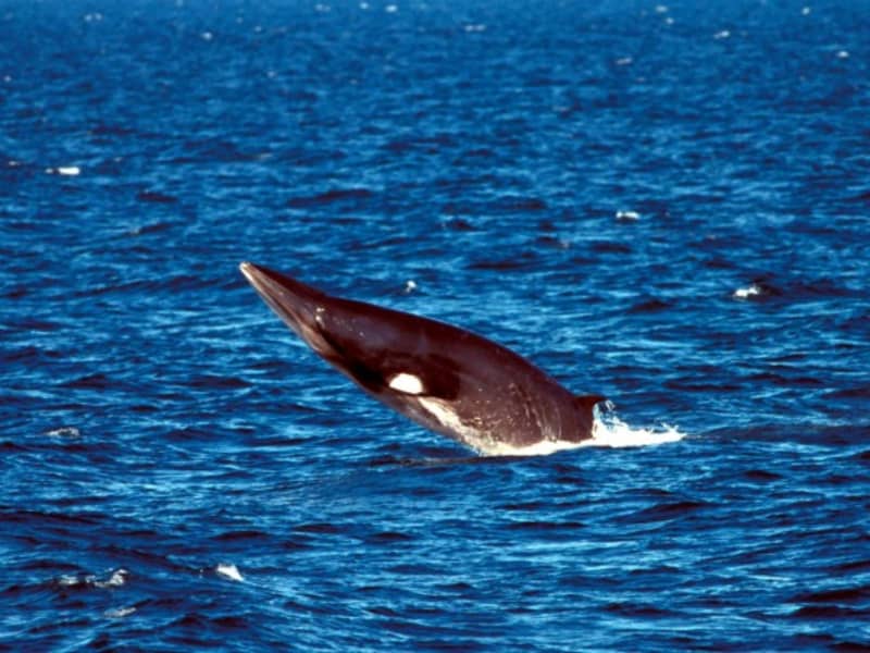
Whales in Reykjanes
The waters surrounding the Reykjanes peninsula are home to dolphins and various species of whales in the warmer months of the year, and in winter as well. Commonly found in the waters off Garður are white beaked dolphins and minke whales, even as close as outside the harbour in Keflavík and nearby. The area is an important habitat for these marine mammals, mainly as a seasonal feeding ground, rich in plankton. These waters provide excellent conditions for such fish species such as sand eel, herring, capelin, haddock and cod to thrive. Humpback whales are also commonly seen in July and August, and occasionally seil whales , fin whales and the enormous blue whales appear at the surface.
View

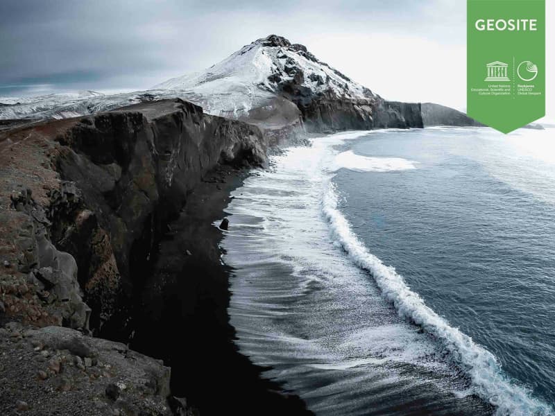
Eldey
A sheer 77 metre high rock protruding out of the sea.
It is about 15 km to the south of the southwestern most tip of the Reykjanes peninsula.The structure of Eldey is basaltic hyaloclastites, and it is 0,3 km2 in area. It is the innermost of a chain of skerries standing on a shallow, submarine ridge, which stretches 45 seamiles offshore to the southwest. The name of this chain is Fuglasker or Eldeyjar. One of those skerries was Geirfuglasker, where the last breeding colonies of the Great Auk was located. Geirfuglasker disappeared mostly from the surface during submarine eruptions in 1830.One of the biggest gannet colonies of the world is still surviving on Eldey. According to a count which was made in 1949 the number of gannets breeding there during the summer was 70.000.
View

Strandarheidi
The Strandarheidi is also called Vatnsleysustrandarheidi. This area comprises of barren lava fields inland from the Vatnsleysa Coast. Originally it offered excellent grazings, vegetated with bushes of birches and willow, but overgrazing and lack of water have changed the landscape drastically. In the area is an interesting sheep shelter called Stadarborg.
Copy right: www.nat.is Used by permission.
View
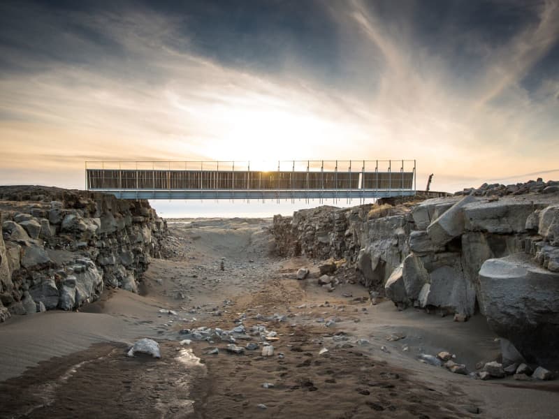
Bridge Between Continents
Note: An increase in seismic activity has been on the Reykjanes Peninsula over the last weeks. As a result, new cracks have formed—or existing ones have reopened—in several locations, including near popular sites such as the Bridge Between Continents.
These cracks can be hard to spot and may pose a danger, especially near cliffs or unmarked areas. We strongly encourage all visitors to stay on marked trails and paths and to avoid getting too close to any visible cracks or edges.
A symbolic bridge between Europe and North America on the Reykjanes Peninsula.
The lava-scarred Reykjanes peninsula lies on one of the world's major plate boundaries, the Mid-Atlantic Ridge. According to the continental drift theory, the Eurasian and North American tectonic plates are continuously drifting apart with great forces under the gaping rifts. As the plates diverge, linear fractures, known as fissures, form due to stresses created by the tension that builds up as the plates move away from each other.
The Bridge between two continents at Sandvík is a small footbridge over a major fissure, which provides clear evidence of the presence of a diverging plate margin. The bridge was built in 2002 as a symbol for the connection between Europe and North America.
One can cross the continental divide on Leif the Lucky's Bridge and take home a personalised certificate at the information center in the Folk museum in Gardur and the Reykjanes Geopark visitor center at Duus Cultural house.
View
Reykjanes nature reserve
A large nature reserve ideal for recreation and to explore in the nature.
The nature reserve is about 300 square kilometres and is by far the largest region of its kind in Iceland. It is bordered in the east by the districts of Gullbringa and Árnessýsla and in the north it connects with the Bláfjöll nature reserve. The western borders of the nature reserve are west of Undirhlíðar and Núpshlíðarháls hill and a straight line to the sea at Selatangar, a former fishermens´ station. The southernmost borders follow the coastline. The only big lake is Kleifarvatn. The land is very hilly, two very distinctive ridges cut through the landscape in NA-SV direction and they are about 300-400 metres above sea level, Núpshlíðarháls and Sveifluháls. Brennisteinsfjöll are located in the easternmost part of the nature reserve and there are a few mountains that are 500-600 metres above sealevel. Seltún is very active hotspring area and was once to become the source for providing the Hafnarfjörður municipality with hot water for space heating. On the coast is the largest birdcliff on the peninsula, Krýsuvíkurberg, where approx. 50.000 seabirds are nesting. Easy access hiking and walking trails are to be found in many places and attractive ponds and lakes are on top of some of the hills.
View

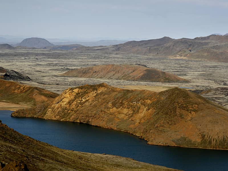
Kleifarvatn
Lake between Sveifluháls and Vatnshlíð.
The lake Kleifarvatn is about 10 km². It is the largest of Reykjanes peninsula and the third largest of southern Iceland. It is about 97 m deep and one of the deepest lakes in Iceland. Its catchment area is small and it has a very limited discharge on the surface. The lake has diminished since year 2000 because of two major earthquakes, which probably opened up fissures at its bottom. In the sixties char fries from Lake Hlidarvatn were released into the lake and have thrived quite well.
In the southernmost part a hot water from some hot springs runs into the lake but elsewhere the lake is very cold. A small fishing lodge is located by the lake. Great place for photographers because of the volcanic surroundings of the lake are unique and beautiful. The story says that a monster in the shape of a worm and size of a medium sized whale lives in the lake.
View

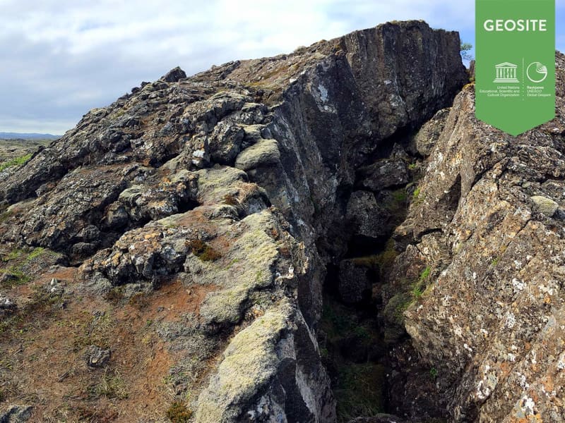
Lambafellsgjá
An open fissure in an oval hyaloclastite mount named Lambafell. The fissure is up to 50 metres deep. It is possible to hike along the entire fissure in the summer time. In the walls of the fissure are excellent outcrops of subglacially formed basaltic pillows.
Location: The walk takes about 1 hour. Take road to Höskuldarvöllur and then drive down to Trölladyngja. Park at the parking at Eldborg and walk east of Eldborg to Lambafell.
View

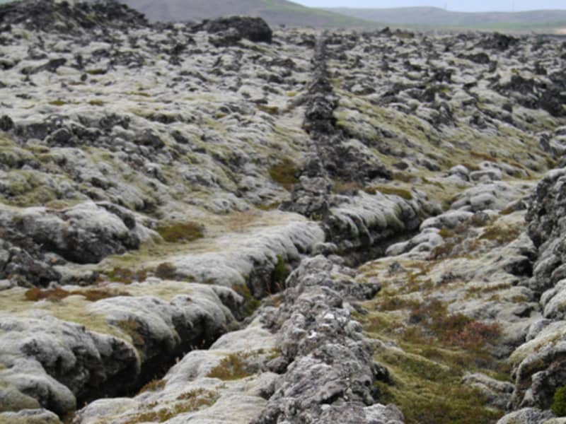
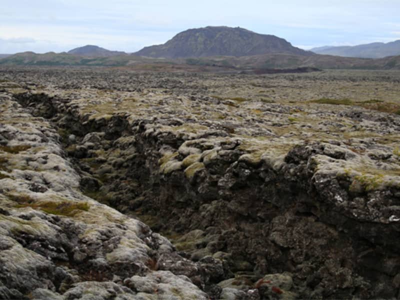
Ogmundarhraun
A lava flow formed in an eruption in the year 1151 AD.
In that year a 25 km long fissure opened obliquely acorss the Reykjanes peninsula. The lava field is located in south of ridge Nupshlidarhals(Vesturhals) and craters in the northern part are part of crater row in the north of Ridge Nupshlidarhals. Ogmundur is a male name in Iceland.
View

Stóra-Eldborg next to Geitahlíð
Eldborg is by far the highest of five craters lying along a volcanic fissure in the slopes of Geitafell, and is often called Stóra-Eldborg (Big-Eldborg). It is steep and made of scoria and spatter. A prominent lava channel branches off to the east. Both Stóra-Eldborg and Litla-Eldborg (Small-Eldborg) are protected. It is possible to hike up to Stóra-Eldborg, which is by many considered the most beautiful crater in the Southwest of Iceland, and from there to Litla-Eldborg where one can look straight down the crater.
Near Grindavík south of road 427 is Stóra-Eldborg and below the road is Litla-Eldborg. The path to Stóra-Eldborg was recently fixed and a new parking lot was built. New information signs will be put up this summer (2022).
View
Stampar
Two volcanic fissures lie from the sea onto land on the western side of Reykjanes and form a series of craters. These crater series have been named Stampar. The crater series are from two periods. This series lies in the SW-NE direction and follow thereby the most common fissure angle in Reykjanes.
The older formed in an eruption from a fissure that was just under 4 km long around 1,800 to 2,000 years ago.
The younger Stampar crater series formed in the Reykjanes Fires in 1210–1240. The row of craters is around 4 km, and the area of the lava field they produced is approximately 4.6 km2. The two craters closest to the road, named Stampar, are at the north end of the crater row. Further south in the crater row are other sizeable craters such as Miðahóll hill, Eldborg the deeper and Eldborg the shallower. Fishermen in earlier times used all these craters as points of reference when out at sea. Most of the craters, however, are low-lying scoria cones and not very prominent.
It may be noted that during the Reykjanes Fires in 1210–1240, there were four lava flows in the Reykjanes and Svartsengi system, as well as submarine eruptions in the seas off Reykjanes.
The Hundred Crater Trail, a signposted trail, lies partly through the Stampar lava field. The trail starts at Valahnúkur in Reykjanes. The trail also passes through the Reykjanes geothermal zone, past slag and scoria cones, the tuff mountain Sýrfell and on to the Stampar craters. From there, the path lies over rough pahoehoe lava and sand dunes, running from the west side of the crater closest to the road, along the row of craters, on to the seaward side of the Reykjanes Power Plant. The craters along the trail are numerous and fragile.
Walking up onto the crater nearest the road is permitted. It is important, however, to make sure that sensitive natural formations are not disturbed.
Location: Road 425 about 2,5 km north of Rauðhólar, short walk from there
View
Stóra-Sandvík
Stóra-Sandvík is a beautiful cove with black sand beach and grassy dunes. Located close to Bridge between Continents, it is the perfect stop while exploring the area.
View

Eldvörp
Eldvörp is the name of scoria and spatter cones in off-set sections that form a row of ten kilometers, and it's surrounding lava covering 20 square kilometers. It dates back from a volcano-tectonic episode between 1210 and 1240 called the Reykjanes Fires. At the center of Eldvörp there are geothermal features and a single borehole. Women from Grindavík used to bake bread in the steam from the lava and a trail called Brauðstígur, or the Bread trail, leads there from the town. Remains of human activity can be found in various places in Eldvörp.
View
Basendar
An ancient fishing outfit and a trading post just south of Stafnes.
It was one of the harbours of the Danish Trade Monopoly posts comprising Hafnir, Stafnes and Midnes. During the night of January 9th 1799 a catastrophic tidal flood devastated Batsendar. It swept most of the houses away and some of the people barely escaped. Only one old woman drowned. This was the most devastating, tidal flood in the history of the country.
How to get there: Road from Sandgerði to Stafnesi. There is a parking and walk from there until you see ruins of the place and old wall made from rocks.
View
Sveifluhals
A lava flow formed in an eruption in the year 1151 AD.
In that year a 25 km long fissure opened obliquely across the Reykjanes peninsula. The lava field is located in south of ridge Nupshlidarhals(Vesturhals) and craters in the northern part are part of crater row in the north of Ridge Nupshlidarhals. Ogmundur is a male name in Iceland.
Located West of Lake Kleifarvatn. Drive road 427 and turn left on road 42 then park at Seltún and walk Preststígur. Walk estimated 2-3 hours up and down.
View

Seltjörn
A pond with good walking paths, picnic facilities and a barbecue.
Next to Seltjörn is Sólbrekkuskógur, a small forest, but sheltered and lovely as it is situated hugging small slopes, with interesting rock formations in a few places.
Next to the pond is an abandoned building that was raised in 1941, this building was used to harvest ice to keep fish cold.
View

Háleyjabunga
Háleyjarbunga is a small, flat lava shield with a large, 20 to 25 meter deep crater.
The shield is at least 9,000 years old. It was formed during a highly effusive lava eruption. The basalt-type is a primitive deep-mantle derived picrite that contains much of the green mineral olivine.
Location: The Háleyjarbunga is close to Reykjanes lighthouse on the tip of Reykjanes. A hikingpath is marked form Gunnuhver over the lavafield to Háleyjarbunga.
Háleyjarbunga is a geosite within Reykjanes Unesco Global Geopark.
View

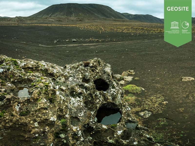
Sundhnúksröðin
A crater row formed in eruption 2.350 years ago.
It created natural harbour condtions in the town Grindavík. Sundahnúkur was used as a landmark for the Grindavík harbour in former times.
View

Hoskuldarvellir
Hoskuldarvellir is a green spot in the lava field to the west of the shield volcano Trolladyngja on the Reykjanes Peninsula in Southwest Iceland. A stream bead there seems to suggest some kind of a discharge of water from the volcano Trolladyngja. When it is active during the melting season of snow or discharge of ground water it runs down the plains and continues to recreate the landscape. Hoskuldarvellir represents the largest green area of the former district of Gullbringusysla.Copy right: www.nat.is Used by permission.
View

Valahnúkamöl
High boulder ridge composed of well rounded stones.
The ridge is about 420 m long, 80 m wide and 10 m high. The rounded stones are 1-3 feet thick.
Created by powerful storms, high waves and surf.
Located: On the tip of Reykjanes, next to cliff Valahnúkur. Take road 425.
View

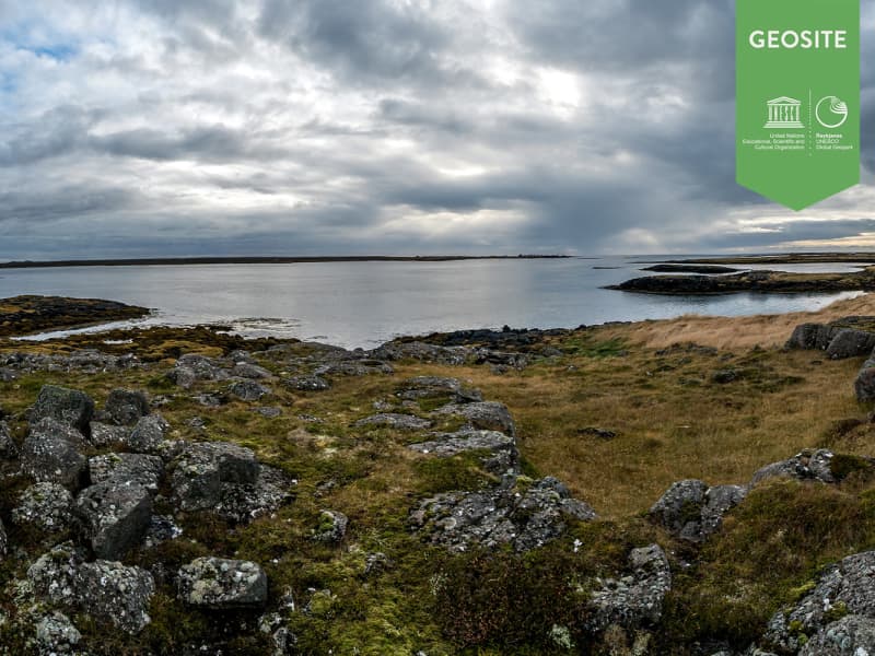
Stakksfjordur
This is a deep southern inlet of the big Faxi Bay between spit Keilisnes in the east and the Stakkur Peak of the Holmur Cliff in the west. The Stakkur Peak is crowned with a lighthouse. The bay was named after a freestanding rock in the sea off Cliff Holmsberg.
Copy right: www.nat.is Used by permission
View
Garðskagi
Including: Garður, Garður Lighthouse, Sandgerði.
Time: Really depends on how long each to will be. Just the driving is estimated to be:
Short version: 30 minutes
Long version: 1 hour
From Keflavík Airport you take road 45 to fishing village Garður (with 4wd it is also possible to follow old trails to the shore to enjoy rich displays nature provides along the coast).
1) There are old trails that lead to fish racks still used to dry fish. Entering the village, you will notice a monument dedicated to the families of fishermen. It depicts women looking out to sea waiting for their husbands to return with the day’s catch.
2) Garður has a beautiful, old church that dates from 1863 and next to it the former pastor’s home which is now educational centre for pastors and an information center about the many fascinating churches in Iceland. A trail beside the church leads down to the shore where you are in close touch with sea birds in their natural habitat.
3) Garðskagi: The headland at the tip of the peninsula at Garðskagi is a great place to observe sea birds. There are two lighthouses where you can get great sea views too. White beach and on the summertime you can play volleyball there. A museum has a unique collection of old machinery and a cafeteria with a deck that lets you observe seals and whales that sometimes are play near the coast while you have refreshments. There is a local handicraft for sale in the old lighthouse guard´s home and a tranquil free campsite with toilets and fresh water.
Next to the lighthouse there is Skagagarðurinn, a protective wall that lay between the farms Kirkjuból to Útskálar.
4) Five minutes drive south on the west coast is the busy fishing harbor of Sandgerði which has an Icelandic Nature Centre with a small aquarium and a handicraft store. There is a display about the French explorer and biologist, Jean-Baptiste Charcout, who went down with his ship the Pourquoi Pas? off the coast in 1936. The village has a well equipped campsite. If you are hungry for real local food experience we recommend the resturant Vitinn.
From Sandgerði you can go back to Keflavík on road Sandgerdisvegur (429).
You can also continue you trip on road 45
5) Heading further south, you will pass an eider duck farm. Another bird shares the farm, the small but very aggressive arctic tern which keeps away all trespassers.
6) Here further on, will see an exceptionally beautiful church at Hvalsnes built of carved stone in 1887. The nation´s greatest psalm poet, Hallgrímur Pétursson served as a clergyman here in the mid 17th century. There is also a lighthouse on the rocky coast at Stafnes. This is the region where an important fishing port thrived at Básendar during the 17th and 18th centuries until the town was literally blown away by a violent sea storm in 1799.
7) Básendar - Ruins of small marketing place and fishing harbour.
8) Gálgar - Gallow cliffs or Hanging Rocks
Return to Keflavík
Star tip: In Sandgerði and Gardur there are very good public swimming pools which are ideal for relax after or meanwhile on the trip.
We hope you had a nice stay in Reykjanes and remember to tag your photos #Reykjanes
View
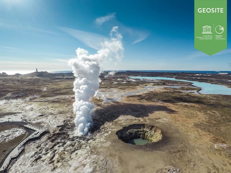
Gunnuhver
The mud pools and steam, vents in south-west Reykjanes.
The area is close to Reykjanes lighthouse and is collectively named Gunnuhver after a female ghost that was laid there. She caused great disturbance until a priest set a trap for her, and she fell into the spring about 400 years ago. Read more about her story in our blog about Gunnuhver.
The mud pools take form where steam from boiling geothermal reservoir water emanates and condenses and mixes with surface water. Accompanying gases such as carbon dioxide and hydrogen sulphide make the water acid. This causes alteration of the fresh lava rock to clay.
Steaming of the ground at Reykjanes increased markedly as a consequence of a pressure drawdown in the geothermal reservoir upon the start of production from the reservoir in 2006.
Iceland´s largest mud pool at present prominent, highest up in the Gunnuhver group. It is 20 meters wide across a rim of mud, boiling vigorously.
Two ramps are located at the Gunnuhver group, on close to Gunnuhver itself where you can look down to the spring and hear the vigorous noise, see the boiling water and feel the power bursting from the ground and the steam on your face. The other ramp is located on Kísilhól a silica hill. From there you have a good view over Gunnuhver group and surroundings.
Gunnuhver stands in the heart of the Reykjanes UNESCO Global Geopark where the North Atlantic ridge rises from the ocean, you find 100 different craters and lava fields, bird cliffs, high geothermal areas, black sand beaches, The Bridge Between Continents, geothermal power plants, lighthouses, and exhibitions.
View
Ósar
Inlet created because of a subsidence.
Important for birdlife and marine biology.
Location: Near small village Hafnir - short walk from road 44
View
The Planets on Reykjanes
Simulations of the planets of the solar system have been placed at relatively correct distances from the sun. Starting from the sun, which is not possible to reach, as it is located inside the closed area of Reykjanes power plant. Other planets are accessible and can be observed when driving the road between Reykjanes power plant and Hafnir.
View

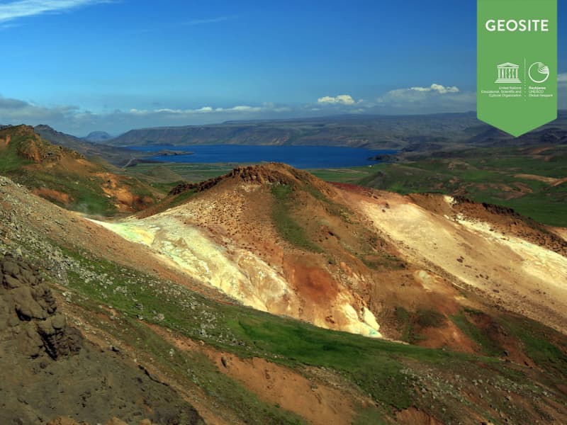
Brennisteinsfjöll
Brennisteinsfjöll, or Sulphur Mountains, are a ridge of late Ice Age hyaloclastite mountains. The highest point is the lava shield Kistufell. Brennisteinsfjöll are lined with volcanic fissures that are not much older than Iceland's settlement. A geothermal area is located in the northern part of the mountains, where sulphur was mined around 1880 with little success. The mines are still visible.
View

Sogasel
Ruins of a shieling(hut), used for cattles during the summer time.
The shieling was located in a crater.
Location: Short walk from road 428 (only open summertime).
View
Gallow cliffs in Stafnes
Place of execution according to an old folk story.
Cliffs, two of which are quite high, with an inlet several fathoms deep between them. A tree between was laied between the two cliffs and men hanged from it a punishment for serious crimes.
Location: About 1 km from Básendar, short walk from road 45
View
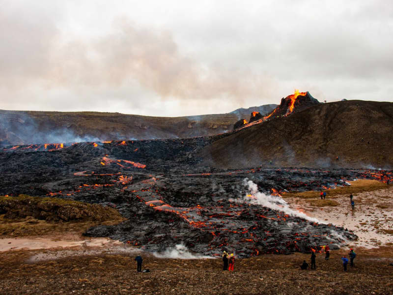
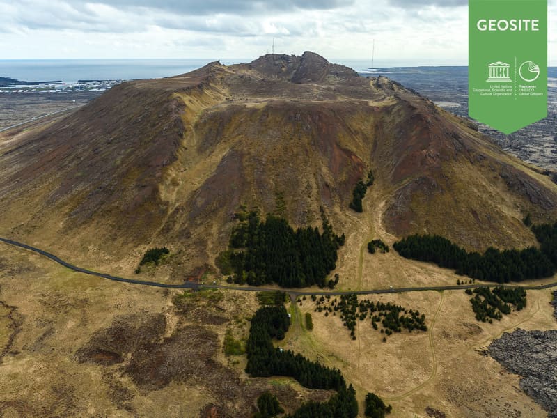
Mt Fagradalsfjall
Mt Fagradalsfjall, the westernmost part of the mountain ridge of the Reykjanes Peninsula, is really a small plateau. Some hyalocaslite ridges protrude, especially in the western part. Its highest elevation is 385 m. above sea level.
As of March 2021 an eruption begun in a valley (Geldingadalur) behind Fagradalsfjall.
Frank M. Andrews, the commander in chief of the American forces in the North-Atlantic area during World War II, with several other high ranking officers, was killed there in a crash. They were arriving from USA and preparing for landing on Keflavík Airport. Only one man survived the crash. He had to wait more than 24 hours for rescue. There can still been found items from the plane.
Location: In the center of Reykjanes Peninsula, north-east of Grindavík.
View
Geitahlid
A table mountain just east of farm Krysuvik.
Geitahlíð is both a doleritie shield volcano and a table mountain. It is 386 metres high on the southern edge of the Reykjanes Mountain Ridge just east of farm Krysuvik. Eldborg the crater is on the souther foot of Geitahlid near the main road.
Location: South of Kleifarvatn, by road 427
View

Kuagerdi
A green patch near a pond next to the old route at the southern edge of Afstapahraun which is a lava field up of Vatnsleysuvík. Reykjanesbraut (41) lies around the patch. There used to be a farmstead and a known place to rest at. Kuagerdi means “Cow Grazings”. Today there as been put up a memorial cross for those who have died in traffic accidents on Reykjanesbraut.
View
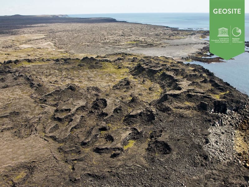
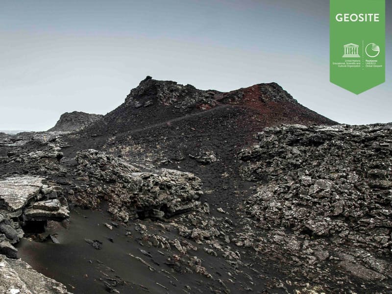
Katlahraun
Katlahraun is lava that flowed about 2,000 years ago and entered the sea. Sudden damming at the shore caused a large, circular lava pond to form. Some lava solidified, but the remaining liquid escaped. The site now contains beautiful and various lava formations.
Katlahraun is a geosite within Reykjanes Uneco Global Geopark.
View

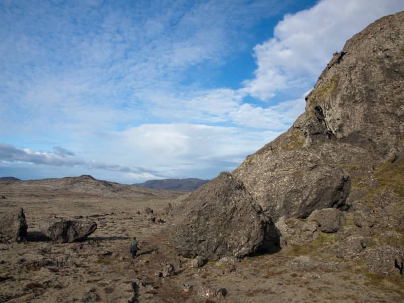
Keilir
Keilir is a hyaloclastite mountain.
It was created during subglacial eruptions during the ice age. Its shape makes it distinctive; according to geologists, it is probably a crater plug. In spite of its steep slopes, it is not too difficult to climb, and the view from its top on a fine day is to be remembered. Keilir is the most distinctive landmark of Reykjanes and a symbol of the Reykjanes peninsula. On top of the mountain is a concrete table with a view direction map on a metal plate.
Location: 4x4 cars can drive on Höskuldarvegi and there is parking at Oddafell and a trail to Keilir.
From Höskuldarvellir there is only a 3 km walk to Keilir.
View
Patterson
Patterson Airport was built in 1942 by the usa navy.
The airport was mainly used to maintain the aircrafts. Next to the airport can be found Subfossils shells, since 20.000-22.000 years ago. They lived shorly before the Late Glacial Maximum at about 18.000 years age. The sea level at that time was about 5-10 m. The airport was closed 1945.
Location: Road 44 at fence on Patterson. Walk north from old ammunition supplier
View
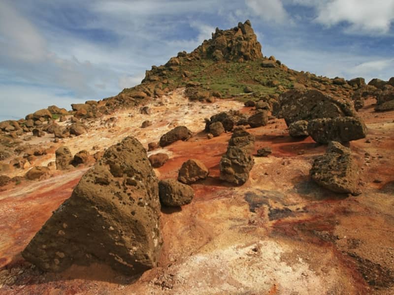
Mt Thorbjorn
A free standing, hyaloclastite mountain north of Grindavik.
It offers great panoramic view over most of the Reykjanes Peninsula on fine days. The northeastern part of the mountain depicts thermal activity an to its north and northeast is an extensive high temperature area. It is split by a fissure called "The Thieves´ Gap" (Thjofagja), occupied by 15 thieves according to the legend. They were eventually overwhelmed and killed by trickery.
View

Méltunnuklif
Lava pile between Grindavík and Krýsuvík.
A good place to ,,read" the history of the peninsula.
Location: Short walk from road 427
View

Seltún
An important high temperature geothermal area.
Many study opportunities due to the great variety of features. A boardwalk leads through the area. Seltún has many mudpots and fumaroles, and minerals deposited from geothermal solutions provide colorful sediments. Good walking paths are around the area and parking.
Setún is a part of Reykjanes nature reserve.
Location: Road 42, parking, near Kleifarvatn.
View

Hrólfsvík - Xenolithes
A well known locality for xenolithes.
Xenolithesa are gabbroic crystal aggregates related to the host magma. The source of the lava is not known nor is its age.
Location: Near Grindavik, walk from road 427
View

Arnarsetur
Arnarsetur is part of one remarkable geological formation of modern times and is mostly undisturbed. It is a short monogenetic volcanic fissure with scoria and spatters craters, formed in an eruption integral to the Reykjanes Fires, a volcano-tectonic episode from 1210 to 1240. The fissure is two kilometres in length and the lava formations that originate from it cover 20 square kilometres. They are rugged and contain lava tubes and remains of human activity. The name Arnarsetur means Eagle's nest and derives from a pair of eagles that lived in the area before.
The Reykjanes fires from 1210 to 1240 AD were the last volcanoes to erupt on the peninsula before Fagradalsfjall in 2021. These fissure swarms produced intense eruptions with curtains of fire. The initial stage of Arnarseturhraun is largely buried under later activity.
The historical records mention some submarine eruptions offshore Reykjanes or by the coastline, part of the metabolism was in the sea causing the island of Eldey (fire island) to arise a few nautical miles from the coast.
Heavy ash appeared and spread a black, fine-grained layer over the Reykjanes peninsula, which nowadays makes the age of lava or human remains comparable.
How to get there?
Arnarsetur is located north of the town Grindavik. It can be reached from Grindavíkurvegur, road no. 43. The exit is about halfway from Reykjanesbraut (41) towards Grindavík.
Nearby: Snorrastaðartjarnir , Bláa Lónið, Svartsengi
View

Brimketill
Brimketill is a small, naturally carved pool, by marine erosion, at the lava shore edge west of the town of Grindavík.
The folklore relates that the pond was regularly occupied by a giantess named Oddný. The viewing platform overlooking Brimketill is just a few steps away from the parking lot starting with a small set of stairs, making the platform inaccessible to wheelchairs. Standing on the platform you risk the possibility of getting soaked as the waves can almost reach the parking lot. Make sure to watch your step while taking in the amazing view and the unrelenting forces of nature. Utmost caution is recommended, especially when travelling with children.
The viewing platform has now been extended and gives visitors a better view over Brimketill. Safety information!
There is no safety supervision of the area.
Visitors travel at their own risk.
The waves can be unpredictable and unexpected.
Ocean currents in the area are extremely powerful.
Strong blasts of wind can be dangerous and unforeseen.
Never leave your child unattended. Hold it at all times on the viewing platform.
Entering the sea may be life-threatening.
Travel safely in Iceland. SafeTravel.is
View

Skálafell
Earthquake fissures in a shield that built up in several eruptions.
In a narrow fissure system. Can find there small caves.
It is most common to walk to Skálafell from parking at Gunnuhver.
View

Eldborg at Höskuldarvellir
The grassy field Höskuldarvellir, northwest of Grænadyngja and Trölladyngja, is bordered in the northeast by a large monogenetic scoria and spatter cone. It has been utilized as a gravel mine and has thus been damaged. Steam vents line the surroundings.
View
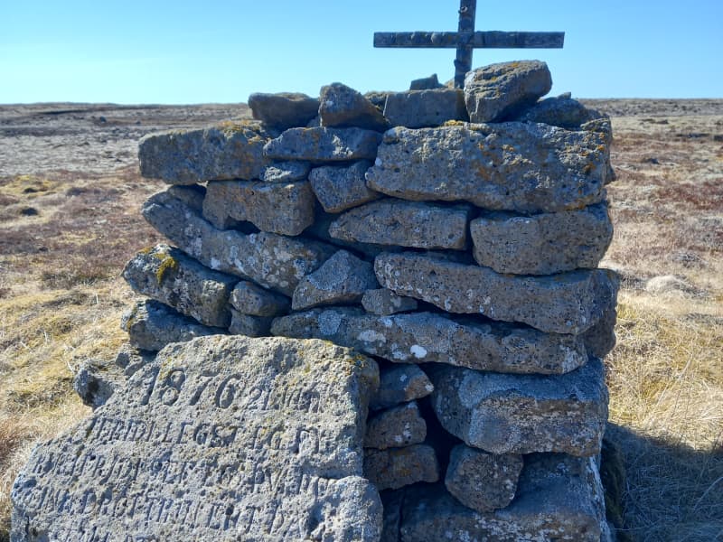
Prestvarða - The Priests Cairn
Prestvarða (The Priest’s Cairn) commemorates Reverend Sigurður Brynjólfsson Sívertsen (1808–1887), a respected priest, educator, and community leader on the Reykjanes Peninsula. After surviving a life-threatening storm near Leira in January 1876, he built this cairn and erected an inscribed stone bearing a verse from the Psalms as a thanksgiving for his deliverance.
The following text tells the story of Reverend Sigurður and the remarkable impact he had on local society.
Rev. Sigurður Brynjólfsson Sívertsen
Rev. Sigurður Brynjólfsson Sívertsen was born at Sel near Reykjavík on 2nd of November 1808 and died on 24th of May 1887. His parents were Steinunn Helgadóttir and Rev. Brynjólfur Sigurðsson.
Rev. Sigurður Br. Sívertsen was married to Helga Helgadóttir. They had nine children, six of whom died in childhood. The three who reached adulthood were Helgi, born in 1836, Sigurður, born in 1843,and Ragnheiður Sigríður, born in 1853.
Sigurður was ordained as a priest on 18 September 1831, aged 23, and served as his father's curate in the parish of Útskálar until he was appointed Priest to the parish on 1 March 1837. Rev. Sigurður retired in June 1886, during his fifty-fifth year of service in the parish of Útskálar, which covered three congregations: Útskálar, Hvalsnes and Kirkjuvogur.
Keflavík belonged to the parish of Útskálar until 1953.
Útskálakirkja Church
Rev. Sigurður Brynjólfsson Sívertsen had Útskálakirkja Church rebuilt in 1861. He personally contributed 632 ISK towards the construction, but the total cost was 3,450 ISK.
He also donated many valuable items to the church, including a silver baptismal bowl, two large candlesticks and an altarpiece.
Several renovations have been carried out on the church over the years, the most recent of which was completed in 2008.
Gerðaskóli
Rev. Sigurður Br. Sívertsen was involved in founding Gerðaskóli, which was established on 7 October 1872, making it one of the oldest continuously operating primary schools in the country. He personally contributed 1,200 krónur towards the construction of the school building, which stood in Gerðar for several years. The current school building was brought into use in 1911 and has been extended several times. Rev. Sigurður was the headmaster of the school for its first fifteen years. When he left his post at the school, it was debt-free.
Rev. Sigurður wrote the Suðurnes Annals, which is a remarkable historical source about the way of life and events in the Suðurnes region in former times and during the Rev. Sigurður's lifetime.
Sveitarstoð og styrkurStöðugt reyndist hannlandi’ og lýð til heillaLífsstarf fagurt vann.
(english)
A pillar of the community,Steadfast and true,For land and people’s welfare,A noble life’s work he did do.
The verse above, from the eulogy for Rev. Sigurður Br. Sívertsen is engraved on a memorial stone dedicated to him, which stands by Gerðaskóli school. Njáll Benediktsson donated the stone in memory of this distinguished man, who was instrumental in founding the primary school in Garður in 1872. The school was built in Gerðar and is named Gerðaskóli.
Gunnar M. Magnúss wrote in his book Undir Garðskagavita (Beneth the Garðskagi Lighthouse) in 1963:
“Thus begins the story of the man who must be considered one of the leading figures of the 19th century for our nation. That was Sigurður Brynjólfsson Sívertsen.”
Students of Gerðaskóli have commemorated this great benefactor of the school on various occasions.
In 2000, on the 1000th anniversary of the adoption of Christianity in Iceland, a theme week was held at Gerðaskóli where all students learned about Rev. Sigurður Br. Sívertsen and, among other things,published a pamphlet about him. Students and school staff walked together to Prestsvarða (Priests Cairn) in Leira.
Short plays were also performed at the community hall in Garður about the founding of Gerðaskóli in 1872 and the events of 1876, when Rev. Sigurður was caught in severe weather in Leira, as described below.
In Suðurnes Annal, Rev. Sigurður Br. Sívertsen gives the following account:
“On Sunday, 2 January 1876, there was a most ferocious storm from the south-west which lasted all night. Boats were blown away and wrecked. Another similar storm hit on the Saturday evening of 22January with torrential rain, following a south-westerly blizzard and frost.”
That evening, as I was returning from Keflavík, where I had baptised a child, I became separated from my travelling companion at Bergsendi. Since I could no longer make out the route, I strayed south of the track above Leira. I did not dare continue, fearing that I might become lost southwards in the heath. My horse had also run away from me.
I then lay down, intending to remain where I was. During the night, my parishioners, at my son’s urging, went out in search of me. The dreadful night passed without anyone finding me, until in the morning two men from my household came upon me. I was still conscious and had some strength left, although I was greatly weakened.
No one believed that I could have survived that night. It was plainly a wondrous work of Almighty God that I should live so long in such weather. Yet I felt well, and it seemed to me as though a shelter had been spread over me; surely I was under a protective covering and fatherly care. Praise be to God for this gift of life. This event in my life I do not wish to forget to mention, and to give God the glory.”
Shortly afterwards, Rev. Sigurður had a cairn built at this place and a verse carved into a large stone slab, which was set up beside the cairn. The inscription on the slab is from Psalm 4, verse 9, and is written as follows:
1876 21. Jan.
Í friði legst ég fyrirÍ friði sef ég því þúeinn drottinn ert þaðsem lætur mig búaóhultann
(English)
In peace I will lie downand in peace I will sleep,for you alone, Lord,make me dwell in safety.
View
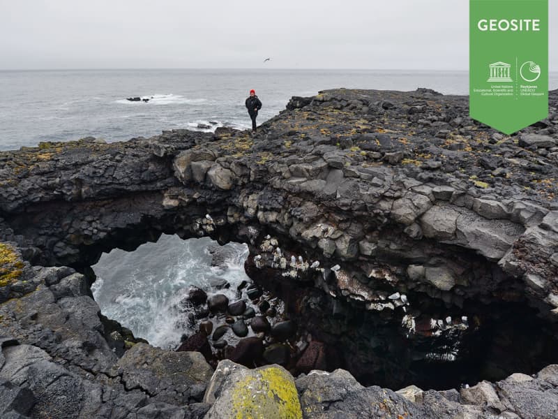
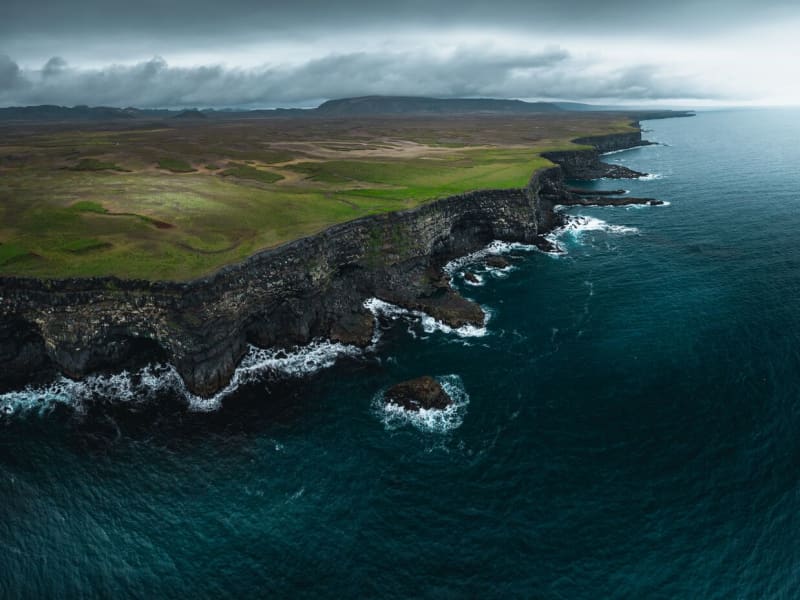
Hafnaberg - Sea-cliffs
Hafnaberg is a long line of sheer sea lava cliffs south of the old fishing hamlet of Hafnir.
Hafnaberg is very popular among hikers and bird watchers as various marine birds nest at the cliffs. A parkingplace is located 4 km from Hafnir on road 44 and from there is a marked path from the road to the cliffs.
Hafnaberg is a geosite in Reykjanes Unesco Global Geopark.
View
Krýsuvík
Popular recreational destination with many interesing hiking paths.
Columns of steam rise skywards, bubbling mud pools play their rhythmical symphony, and the banks around the hot springs are coloured green, yellow and red. The Grænavatn and Gestastaðavatn lakes and the two small pools on each side of the road further south, Augun (Eyes), are all explosion craters created by volcanic eruptions at various times. Grænavatn lake is the largest, some 46 metres deep, with green water due to thermal algae and crystals which absorb the sun. The main geothermal areas in Krýsuvík are Seltún, Hverahvammur, Hverahlíð, Austurengjar, the southern part of Kleifarvatn and Sveifla beneath Hettutindur. The Fúlipollur mud spring is east of the main road.Lake Kleifarvatn is the largest lake on the Reykjanes peninsula, and the third-largest lake of southern Iceland, 9.1 km². It is also one of the country's deepest lakes, at 97 metres. It varies in size over the year. Since 2000 it has been shrinking, after two major earthquakes probably opened up fissures on the lake bottom. Trout fry were released into the lake in the 1960s, and the fish have thrived quite well. According to legends a monster in the shape of a serpent, as big as a medium-sized whale, lurks in the lake. Krýsuvík was once a separate parish, with one of the largest estate farms in the country, and many tenants crofts. The church, built in 1857, was restored in 1964 and is part of the National Museum's Historic Buildings Collection. On the hill and around it, traces of the old farmhouse and other buildings can still be seen, although they are somewhat overgrown with grass. It should be kept in mind that the area's magnificent nature is very delicate and must be treated with great care and respect.
Location: By road 42. 1km west of Grænavatn which is 3km south-west of Kleifarvatn
View
Gallow Cliffs near Hagafell
Cliffs known as Gallows Cliffs or Hanging Rocks.
The cliffs were used to execute thieves captured in Þorbjarnarfell according to an old folk story.
Location: From road 43 there is a short walk.
View

Grænavatn
Two maar type explosion craters, probably over 6000 years old.
The age difference between the craters is probably small. Both of the craters are lake-filled today. The trend of the crater rows is the same as that of earthquake fractures of the Reykjanes Peninsula, generally trend SW-NE.
Location: Close to road 428.
View
Festarfjall
A eroded subglacial volcano.
A section of a small hyaloclastite hill is exposed in the costal cliffs. A dyke named Festi(ladder), evidently the feeder for Festarfjall, passes up through the basement and the Festarfjall sequence, branching towards the base of the lavas. The story say that Festi is a neckless of a woman-troll.
Location: Near highway 427
View

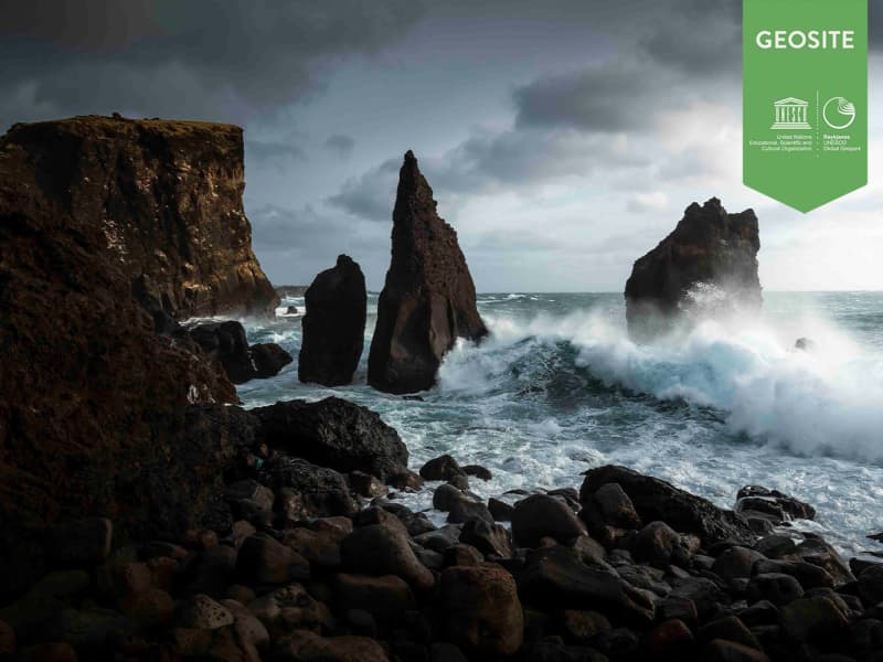
Karlinn
Karlinn („The Man“) is a 50-60 m high seacliff, an eroded volcanic plug, which stands high and mighty just off the coast of Valahnúkur. Karlinn is popular spot with visitors and especially among photographers, as it is truly picturesque when the unremitting waves hit the rock.
View

Hrútagjárdyngja (shield)
Hrútagjárdyngja is a 6,000 to 6,500 years old ava shield, plus a lava flow that covers 80-100 sq. km of land. That volume of lava is at least 3 cu. km. Besides a large top carter, the upper part is cut by deep ravines, probably due to magma injections, causing the whole structure to inflate.
Location: Sign can be found from road 42 that leads to the shield.
View
Drykkjarsteinn
A rock with three holes, shape like bowls.
Most wanted stop for travellers that had to go to either to Grindavik or Krýsuvík. It is located were these two old roads meet.
The story says that one is for a dog, one for a man and the third for a horse. The water is holy and people could always trust that there would be water to drink.
Location: Short walk from road 427.
View
Kapelluhraun
The rugged and barren Chapel Lava Field or the New Lava Field spreads between the town Hafnarfiord and Cove Straumsvik. According to chronological research, it was created between 1010 and 1020. Directly opposite to the Aluminium Smelter is a lava mound with a ruin of a prayer chapel, probably dating back to catholic times. In 1950 it was examined and a statuette of St Barbara was discovered. A replica of the statuette was made and placed in the ruin, but the original is kept in the National Museum in Reykjavik. A large area of the lava field around the chapel ruin has been quarried for street construction and house foundations and flattened.Copy right: www.nat.is Used by permission.
View
Snorrastaðatjarnir /Háibjalli
A popular recreational area.
Pounds, rich of vegetation and important resting place for migration birds.
Next to the pounds is Háibjalli, a 10 m high fault.
Location: Road 43 near Seltjörn and Sólbrekkuskógur.
View
Almenningur
Patch of lava field in Vatnsleysustrond county. Located between two lava fields Kapelluhraun and Afstappahraun. It came from Hrútárgjárdyngju that erupted over 7000 years ago. There used to be a forest but like in other places in Iceland it was gone due to exploitation and grazing. In the area you can find one of many Gvendarbrunnur and on the south side of Reykjanesbraut there are Hvassahraunskatlar.
The name Almenningur means "Common Grazings" and they still share it.
Location: Vatnsleysuströnd
View
Valahnúkur
Note: From 2016, cracks have been visible on the tip of the cliff, and access has been limited. In recent weeks, an increase in seismic activity has been on the Reykjanes Peninsula. As a result, new cracks have formed—or existing ones have reopened—in several locations, including near popular sites such as the Valahnúkur Cliffs.
These cracks can be hard to spot and may pose a danger, especially near cliffs or unmarked areas. We strongly encourage all visitors to stay on marked trails and paths and to avoid getting too close to any visible cracks or edges.
VALAHNÚKUR Cliff
Valahnúkur is composed of tuff layers, pillow lava and breccia. The mountain was formed in a single eruption and shows evidence of the different phases of the eruption. The tuff forms in explosive eruption, while the pillow lava forms when the lava erupts underwater.
Tuff
The mixture of lava rocks and hardened volcanic ash found in Valahnúkur is called tuff. Tuff forms when 1200°C hot lava rapidly cools in water. This forms glass fragments, as crystals do not have time to grow. The fragments quickly transform into tuff.
Breccia
Lower down in Valahnúkur is a diagonal layer of breccia. Breccia forms when slag or ash forms angled slopes. Individual pillows or parts thereof roll down the slope, are covered with ash and form the breccia layer.
Pillow lava
Pillow lava is one of the most common lava types on Earth, as it is the most common lava that erupts from the oceanic crust. These strange pillows form in eruptions under water or glaciers. Such eruptions are often where the pressure is too high to allow steam explosions to occur. They can also form when there is little or no gas in magma that rapidly pushes out as flowing lava. A glassy coating forms over the pillows as the magma cools rapidly. They are often several metres in length but only 10–30 cm in diameter. When examining a cliff wall with a cross-section of such lava, each bulbous formation looks like a ball or a pillow. The pillow lava in Valahnúkur probably formed in a sub-glacial eruption.
View
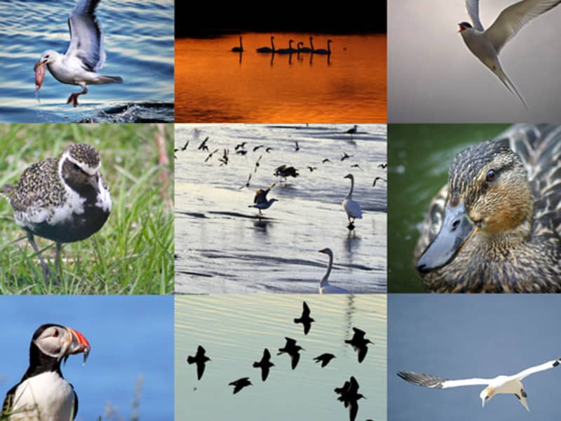
Birdlife
On the Krýsuvíkurberg and Hafnaberg cliffs, thousands of seabirds nest each summer. The most common are guillemot, razorbill,Brünnich's guillemot, kittiwake, puffin, black guillemot, fulmar and cormorant. Krýsuvíkurberg is 50 metres high, and about 57.000 pairs of seabirds nest on these cliffs. The highest point of Hafnaberg is 43 metres, and its estimated population of seabirds is 6.000 pairs. Fourteen kilometres off the southwest of the peninsula is Eldey island, home to one of the largest gannet colonies in the world. The gannet is the largest seabird in the north Atlantic ocean, and about 16.000 pairs nest each year on the island, which is only 0.3 km² in area, and up to 77 metres high. Often seen between the mainlandand the island are dolphins or whales blowing. The great skua and arctic skua are common in summer: scavengers snatching their food from other seabirds. By nature the skua is not able to dive for food like other seabirds. Other common birds on the coast are gulls, such as the great and lesser black-backed, glaucous and herring gulls.
The arctic tern is among the most common birds in the peninsula, mostly found in colonies on the tip of Reykjanes, east of Grindavík and between Garður and Sandgerði. Whimbrels which breed in the Suðurnes area spend the winter in Africa, and arctic terns migrate to the Antarctic. The golden plover, oystercatcher and snipe are migratory birds which are common in the area, while the purple sandpiper is one of the few Icelandic waders which does not migrate.
Among passerines, the redwing and snow bunting are common, and the starling remains in Iceland all year round. The largest passerine is the raven. The eider is by far the most common species of duck in Iceland. In the Suðurnes area the eider is economically important, as farmers harvest the valuable down from eider nests. The greylag goose nests in the lowlands, and the whooper swan is the only species of swan which breeds in Iceland.
View
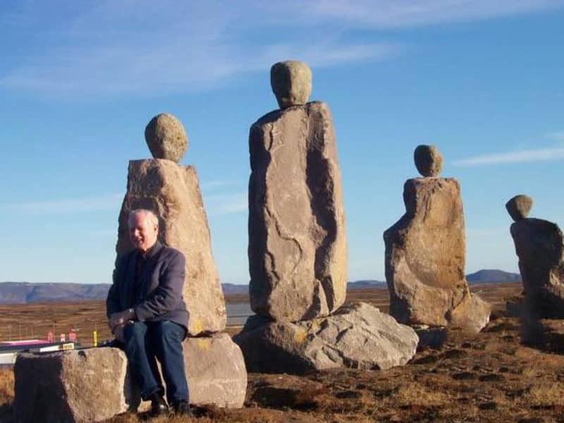
Sagnatröllin (Trolls)
The trolls are stone figures that can be found around Reykjanesbær, and they make a big impression on the environment. Áki Gränz created the figures, he was an artist and former chairman of the town council of Njarðvík. Áki's idea was to preserve toponyms and stories related to the area by using trolls. Among the trolls, you can count the Tyrkjavörður trolls, the Grænáskirkja, the Nástrandartrolls, the Stapat trolls, Frey and Freyja and Sýslumanninn. The trolls are made of stones from Helguvík. Not all trolls, however, are trolls because there are also elves. At the top of Grænásbrekka stands a family of elves, and they are smaller than other stone figures. The family stands on Grænás, where people believed there was an elven church, Grænáskirkja.
View
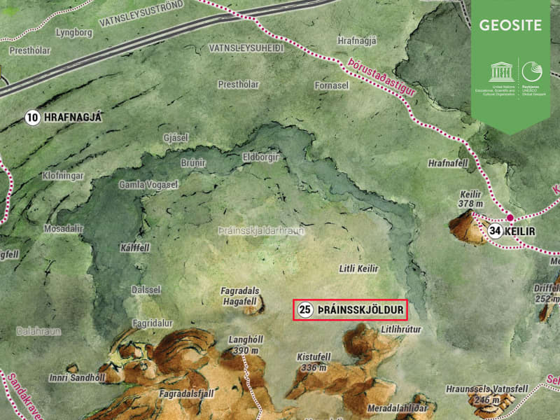
Thrainsskjoldur
Thrainsskjoldur is an extensive lava mound north of Mt Fagradalsfjall. There are no resent remains of volcanic activity on its top, but vast lava areas around it suggest great volcanic activity most of the way around it during the recent Holocene epochs. Among its products is the lava field surrounding Mt Keilir, the hills Keilisborn, and almost overrunning the former Mt Small Keilir. The communities of Vogar and Vatnsleysustrond are located on top of the lava field of the craters around the Thrainsskjöldur Shield Volcano, which was one of the most active and productive volcanoes of the Reykjanes Area.
View

Sogin
A depression in a hyaloclastite ridge.
The area is colourful due to intese high temperature alternation and a few mud pools and solfataras.
Location: During summertime it is possible to drive on road Vígdísarvellir (428) on well-equipped cars but it is closed during winter. On winter it is possible to walk from road Krýsuvíkurvegur (42).
View

Tjarnir á Vatnsleysuströnd
Seaweed-coverd rocks which are part of the Þráinsskjöldur Lava Flow.
They were formed about 10,000 years ago.
Due to the pourous roks that form the foundation of this part of Iceland fresh water seeps from the ground in many places.
Located near town Vogar.
View
Krýsuvíkurberg
Sea cliffs with colorful birdlife.
Accessible and very interesting 15 km wide and 40 m high sea cliffs which attract over 57 thousand seabird couples every year to breed.
Location: Close to Hælsvík, walk from road 427
View
Grænadyngja
Grænadyngja is a steep hyaloclastite mountain west of the Sog-geosite. It has the same geolocical features as Trölladyngja mountain. It is a geothermal site with volcanic fissures. From the fissures there have been various lava flows towards the west of the peninsula, including Afstapahraun (aa type) close to Reykjanesbraut (road nr. 41) to the Keflavik International Airport.
Grænadyngja is popular for hiking. The best way to aproach the mountain is by car, exiting road nr. 41 on the crossroads towards Mt. Keilir and road nr. 420.
Mt. Grænadyngja is a geosite in Reykanes Unesco Global Geopark along with Mt. Trölladyngja.
View
Grænadyngja and Trolladyngja
Grænadyngja and Trölladyngja are steep hyaloclastite mountains west of the Sogin geosite. They are surrounded by young volcanic fissures, geothermal sites and beautiful colours. The two mountains are associated with various lava flows, including Afstapahraun close to the Keflavík International Airport main road.
Four kilometers on road 41 east from Mt. Keilir.
View

Rosmhvalanes
Flat point at the northwestern part of the Reykjanes Peninsula.
It is from glacial periods and is between Ytri-Njarðvík and Kirkjuvog.
Rosmhvalur was another name for Walrus and the story says that they used to live there.
There is a new sign that shows a good way to drive around Reykjanes.
View
