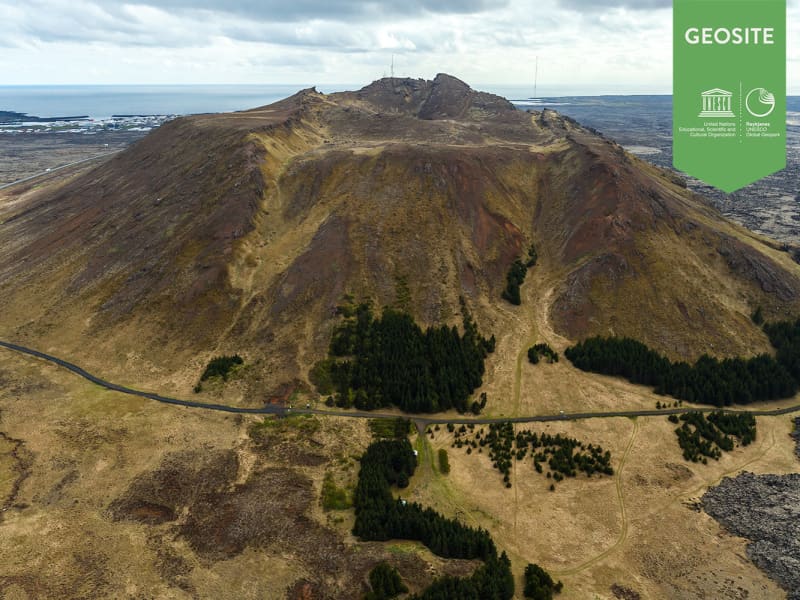
Mt Thorbjorn
A free standing, hyaloclastite mountain north of Grindavik.
It offers great panoramic view over most of the Reykjanes Peninsula on fine days. The northeastern part of the mountain depicts thermal activity an to its north and northeast is an extensive high temperature area. It is split by a fissure called "The Thieves´ Gap" (Thjofagja), occupied by 15 thieves according to the legend. They were eventually overwhelmed and killed by trickery.
View
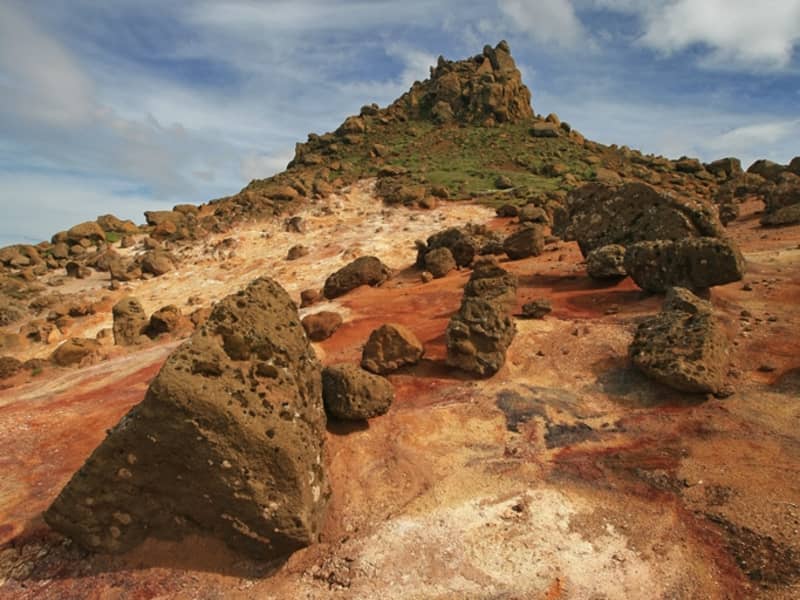
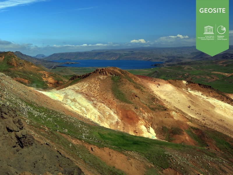
Krýsuvík
Popular recreational destination with many interesing hiking paths.
Columns of steam rise skywards, bubbling mud pools play their rhythmical symphony, and the banks around the hot springs are coloured green, yellow and red. The Grænavatn and Gestastaðavatn lakes and the two small pools on each side of the road further south, Augun (Eyes), are all explosion craters created by volcanic eruptions at various times. Grænavatn lake is the largest, some 46 metres deep, with green water due to thermal algae and crystals which absorb the sun. The main geothermal areas in Krýsuvík are Seltún, Hverahvammur, Hverahlíð, Austurengjar, the southern part of Kleifarvatn and Sveifla beneath Hettutindur. The Fúlipollur mud spring is east of the main road.Lake Kleifarvatn is the largest lake on the Reykjanes peninsula, and the third-largest lake of southern Iceland, 9.1 km². It is also one of the country's deepest lakes, at 97 metres. It varies in size over the year. Since 2000 it has been shrinking, after two major earthquakes probably opened up fissures on the lake bottom. Trout fry were released into the lake in the 1960s, and the fish have thrived quite well. According to legends a monster in the shape of a serpent, as big as a medium-sized whale, lurks in the lake. Krýsuvík was once a separate parish, with one of the largest estate farms in the country, and many tenants crofts. The church, built in 1857, was restored in 1964 and is part of the National Museum's Historic Buildings Collection. On the hill and around it, traces of the old farmhouse and other buildings can still be seen, although they are somewhat overgrown with grass. It should be kept in mind that the area's magnificent nature is very delicate and must be treated with great care and respect.
Location: By road 42. 1km west of Grænavatn which is 3km south-west of Kleifarvatn
View
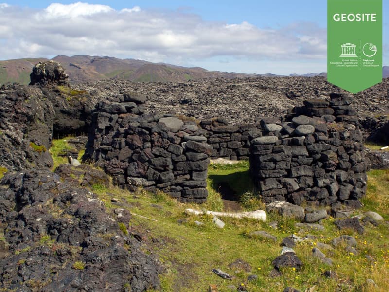
Selatangar
Selatangar was a big fishing outfit between Grindavik and Krysuvik.
It was abolished after 1880. Extended ruins of the abodes and other houses are still very prominent in the landscape. They have been declared inviolate. During the latter part of the 19th century ghosts started haunting the settlement. Driftwood was in abundance at Selatangar in the past, but less nowadays. The surroundings are grandious, low mountains and lava fields.
How to get there: A track for 4wd-vehicles lies down to the ruins on the coast from the road to Isolfsskali.
View
Basendar
An ancient fishing outfit and a trading post just south of Stafnes.
It was one of the harbours of the Danish Trade Monopoly posts comprising Hafnir, Stafnes and Midnes. During the night of January 9th 1799 a catastrophic tidal flood devastated Batsendar. It swept most of the houses away and some of the people barely escaped. Only one old woman drowned. This was the most devastating, tidal flood in the history of the country.
How to get there: Road from Sandgerði to Stafnesi. There is a parking and walk from there until you see ruins of the place and old wall made from rocks.
View
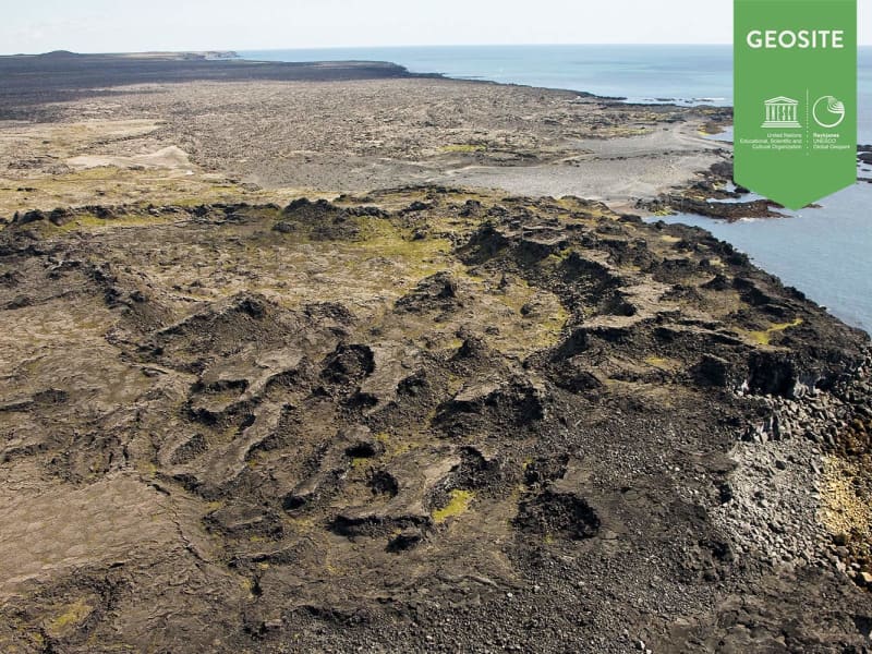
Katlahraun
Katlahraun is lava that flowed about 2,000 years ago and entered the sea. Sudden damming at the shore caused a large, circular lava pond to form. Some lava solidified, but the remaining liquid escaped. The site now contains beautiful and various lava formations.
Katlahraun is a geosite within Reykjanes Uneco Global Geopark.
View
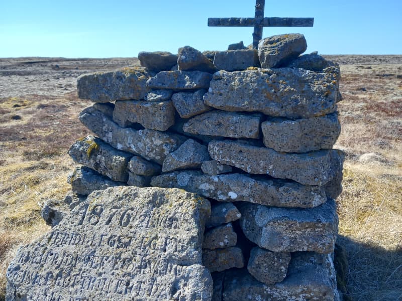
Prestvarða - The Priests Cairn
Prestvarða (The Priest’s Cairn) commemorates Reverend Sigurður Brynjólfsson Sívertsen (1808–1887), a respected priest, educator, and community leader on the Reykjanes Peninsula. After surviving a life-threatening storm near Leira in January 1876, he built this cairn and erected an inscribed stone bearing a verse from the Psalms as a thanksgiving for his deliverance.
The following text tells the story of Reverend Sigurður and the remarkable impact he had on local society.
Rev. Sigurður Brynjólfsson Sívertsen
Rev. Sigurður Brynjólfsson Sívertsen was born at Sel near Reykjavík on 2nd of November 1808 and died on 24th of May 1887. His parents were Steinunn Helgadóttir and Rev. Brynjólfur Sigurðsson.
Rev. Sigurður Br. Sívertsen was married to Helga Helgadóttir. They had nine children, six of whom died in childhood. The three who reached adulthood were Helgi, born in 1836, Sigurður, born in 1843,and Ragnheiður Sigríður, born in 1853.
Sigurður was ordained as a priest on 18 September 1831, aged 23, and served as his father's curate in the parish of Útskálar until he was appointed Priest to the parish on 1 March 1837. Rev. Sigurður retired in June 1886, during his fifty-fifth year of service in the parish of Útskálar, which covered three congregations: Útskálar, Hvalsnes and Kirkjuvogur.
Keflavík belonged to the parish of Útskálar until 1953.
Útskálakirkja Church
Rev. Sigurður Brynjólfsson Sívertsen had Útskálakirkja Church rebuilt in 1861. He personally contributed 632 ISK towards the construction, but the total cost was 3,450 ISK.
He also donated many valuable items to the church, including a silver baptismal bowl, two large candlesticks and an altarpiece.
Several renovations have been carried out on the church over the years, the most recent of which was completed in 2008.
Gerðaskóli
Rev. Sigurður Br. Sívertsen was involved in founding Gerðaskóli, which was established on 7 October 1872, making it one of the oldest continuously operating primary schools in the country. He personally contributed 1,200 krónur towards the construction of the school building, which stood in Gerðar for several years. The current school building was brought into use in 1911 and has been extended several times. Rev. Sigurður was the headmaster of the school for its first fifteen years. When he left his post at the school, it was debt-free.
Rev. Sigurður wrote the Suðurnes Annals, which is a remarkable historical source about the way of life and events in the Suðurnes region in former times and during the Rev. Sigurður's lifetime.
Sveitarstoð og styrkurStöðugt reyndist hannlandi’ og lýð til heillaLífsstarf fagurt vann.
(english)
A pillar of the community,Steadfast and true,For land and people’s welfare,A noble life’s work he did do.
The verse above, from the eulogy for Rev. Sigurður Br. Sívertsen is engraved on a memorial stone dedicated to him, which stands by Gerðaskóli school. Njáll Benediktsson donated the stone in memory of this distinguished man, who was instrumental in founding the primary school in Garður in 1872. The school was built in Gerðar and is named Gerðaskóli.
Gunnar M. Magnúss wrote in his book Undir Garðskagavita (Beneth the Garðskagi Lighthouse) in 1963:
“Thus begins the story of the man who must be considered one of the leading figures of the 19th century for our nation. That was Sigurður Brynjólfsson Sívertsen.”
Students of Gerðaskóli have commemorated this great benefactor of the school on various occasions.
In 2000, on the 1000th anniversary of the adoption of Christianity in Iceland, a theme week was held at Gerðaskóli where all students learned about Rev. Sigurður Br. Sívertsen and, among other things,published a pamphlet about him. Students and school staff walked together to Prestsvarða (Priests Cairn) in Leira.
Short plays were also performed at the community hall in Garður about the founding of Gerðaskóli in 1872 and the events of 1876, when Rev. Sigurður was caught in severe weather in Leira, as described below.
In Suðurnes Annal, Rev. Sigurður Br. Sívertsen gives the following account:
“On Sunday, 2 January 1876, there was a most ferocious storm from the south-west which lasted all night. Boats were blown away and wrecked. Another similar storm hit on the Saturday evening of 22January with torrential rain, following a south-westerly blizzard and frost.”
That evening, as I was returning from Keflavík, where I had baptised a child, I became separated from my travelling companion at Bergsendi. Since I could no longer make out the route, I strayed south of the track above Leira. I did not dare continue, fearing that I might become lost southwards in the heath. My horse had also run away from me.
I then lay down, intending to remain where I was. During the night, my parishioners, at my son’s urging, went out in search of me. The dreadful night passed without anyone finding me, until in the morning two men from my household came upon me. I was still conscious and had some strength left, although I was greatly weakened.
No one believed that I could have survived that night. It was plainly a wondrous work of Almighty God that I should live so long in such weather. Yet I felt well, and it seemed to me as though a shelter had been spread over me; surely I was under a protective covering and fatherly care. Praise be to God for this gift of life. This event in my life I do not wish to forget to mention, and to give God the glory.”
Shortly afterwards, Rev. Sigurður had a cairn built at this place and a verse carved into a large stone slab, which was set up beside the cairn. The inscription on the slab is from Psalm 4, verse 9, and is written as follows:
1876 21. Jan.
Í friði legst ég fyrirÍ friði sef ég því þúeinn drottinn ert þaðsem lætur mig búaóhultann
(English)
In peace I will lie downand in peace I will sleep,for you alone, Lord,make me dwell in safety.
View
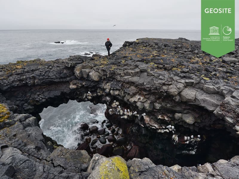
Hafnaberg - Sea-cliffs
Hafnaberg is a long line of sheer sea lava cliffs south of the old fishing hamlet of Hafnir.
Hafnaberg is very popular among hikers and bird watchers as various marine birds nest at the cliffs. A parkingplace is located 4 km from Hafnir on road 44 and from there is a marked path from the road to the cliffs.
Hafnaberg is a geosite in Reykjanes Unesco Global Geopark.
View
Sveifluhals
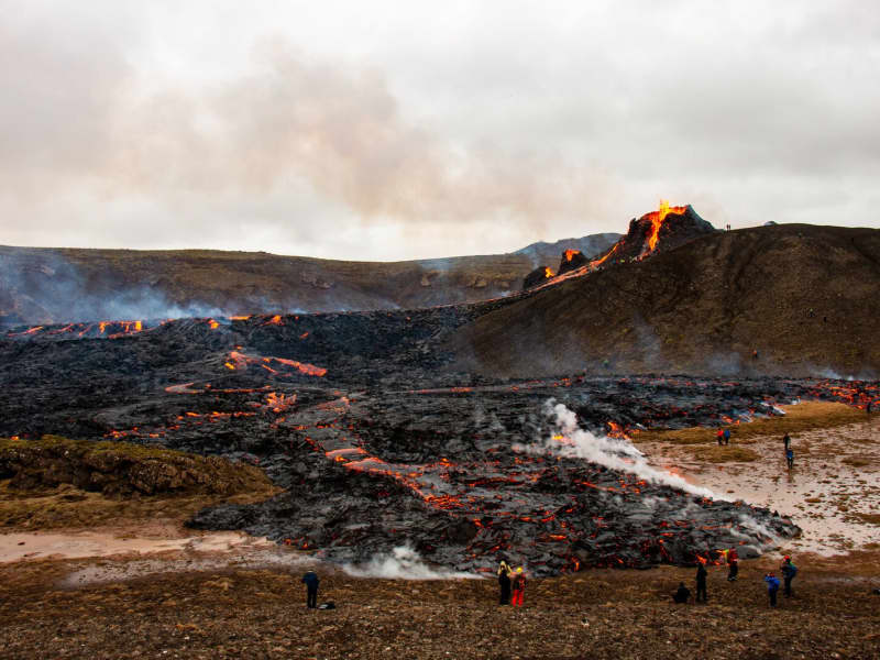
A lava flow formed in an eruption in the year 1151 AD.
In that year a 25 km long fissure opened obliquely across the Reykjanes peninsula. The lava field is located in south of ridge Nupshlidarhals(Vesturhals) and craters in the northern part are part of crater row in the north of Ridge Nupshlidarhals. Ogmundur is a male name in Iceland.
Located West of Lake Kleifarvatn. Drive road 427 and turn left on road 42 then park at Seltún and walk Preststígur. Walk estimated 2-3 hours up and down.
View
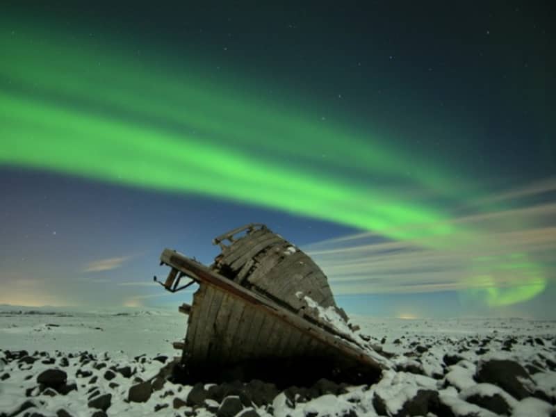
Northern lights - Aurora Borealis
Auroras are associated with the solar wind, a flow of ions continuously flowing outward from the sun. The Earth´s magnetic field traps these particles, many of which travel toward the poles where they are accelerated toward Earth. Collisions between these ions and atmospheric atoms and molecules causes energy releases in the form of auroras appearing in large circles around the poles. Auroras are more frequent and brighter during the intense phase of the solar cycle when coronal mass ejections increase the intensity of the solar wind. Seen from space, these fiery curtains form a thin ring in the shape of a monk´s tonsure.The Northern Lights occur high above the surface of the earth where the atmosphere has become extremely thin, in an altitude of 100-250km
In the past theories have been proposed to explain the phenomenon. These theories are now obsolete. Benjamin Franklin theorized that the mystery of the Northern Lights was caused by a concentration of electrical charges in the polar regions intensified by the snow and other moisture.
The first Old Norse account of norðrljós is found in the Norwegian chronicle Konungs Skuggsjá from AD 1230. The chronicler has heard about this phenomenon from compatriots returning from Greenland and he gives tree possible explanations: that the ocean was surrounded by vast fires, that the sun flares could reach around the world to its night side, or the glaciers could store energy so that they eventually became fluorescent.
Usually from late September until the beginning of April, the Northern Lights can be seen in Iceland in most places. In dark areas away from city lights these are best seen. Important one chooses the right evening with clear skies.
View
Bridge Between Continents
Note: An increase in seismic activity has been on the Reykjanes Peninsula over the last weeks. As a result, new cracks have formed—or existing ones have reopened—in several locations, including near popular sites such as the Bridge Between Continents.
These cracks can be hard to spot and may pose a danger, especially near cliffs or unmarked areas. We strongly encourage all visitors to stay on marked trails and paths and to avoid getting too close to any visible cracks or edges.
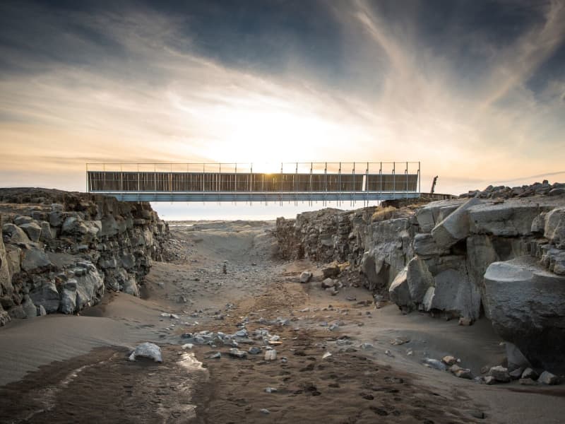
A symbolic bridge between Europe and North America on the Reykjanes Peninsula.
The lava-scarred Reykjanes peninsula lies on one of the world's major plate boundaries, the Mid-Atlantic Ridge. According to the continental drift theory, the Eurasian and North American tectonic plates are continuously drifting apart with great forces under the gaping rifts. As the plates diverge, linear fractures, known as fissures, form due to stresses created by the tension that builds up as the plates move away from each other.
The Bridge between two continents at Sandvík is a small footbridge over a major fissure, which provides clear evidence of the presence of a diverging plate margin. The bridge was built in 2002 as a symbol for the connection between Europe and North America.
One can cross the continental divide on Leif the Lucky's Bridge and take home a personalised certificate at the information center in the Folk museum in Gardur and the Reykjanes Geopark visitor center at Duus Cultural house.
View