New hazard map for the eruption site
The Icelandic MET office has published a new and updated hazard map
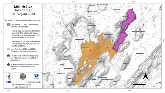
10.08.2023
An updated hazard map for the eruption site
Earlier this week the eruption that started on the 10th of July, ended and all closures were lifted.
Today the Icelandic MET office has published an updated hazard map for the area with information that you are advised to follow when visiting the site.
The eruption site is still a dangerous site. Stay alert and follow the instructions.
- High temperatures characterize the lava field. The solidified crust can be very thin in places with very hot and molten lava underneath.
- The edges of the new lava field are unstable and large chunks of lava can fall suddenly.
- The new lava continues degassing and hazardous gases can collect in depressions.
- As a result of past activity there are fractures in the area that pose danger.
