An eruption has started in Reykjanes and remaining Grindavik residents have been evacuated.
Eruption viewing platform now available
Recently a small viewing platform was set up on Grindavikurvegur, by the start of the new road that leads to the Blue Lagoon.
A new eruption likely
According to the latest Met Office data, Magma continues accumulating under Svartsengi. A magma run or a volcanic eruption is expected in the next two to three weeks.
Original road to Blue Lagoon reopened
Grindavikurvegur has been reopened for access to the Blue Lagoon - however, access to Grindavik remains closed.
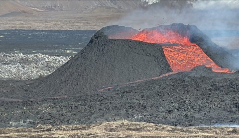
Recent eruption has stopped
The recent eruption that began on May 29th, came to an end.
Updates Regarding Ongoing Eruption and Accessibility
Stay up to date on the latest information - we answer your frequently asked questions below.
Mt. Fagradalsfjall Hiking Trail Is Now Open
The road closures have now been moved, allowing access to the Mt. Fagradalsfjall hiking trail, as well as many other natural highlights.
Blue Lagoon Reopens
All Blue Lagoon facilities are open again as of today (June 11th 2024).
Eruption ongoing and updated road closures
Lava closes road no. 43, Grindavíkurvegur
Eruption in Reykjanes - updated closure boundaries
An eruption has started in Reykjanes and an evacuation plan has been activated around Grindavík.
The Blue Lagoon is open for visitors
The eruption is still ongoing and closures will remain unchanged.
Temporary closure on road no. 43
Due to gas pollution from the eruption and unfavourable wind direction